
The complete guide for UK travellers: when the Northern Lights actually appear, why the Ring Road takes longer than you think, the interior highlands nobody shows you, what it genuinely costs, and how to choose between summer Iceland and winter Iceland — because they’re completely different trips.
Reading time: 17 minutes | Last updated: 2026
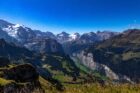
Iceland sits three hours from London and looks like nowhere else on Earth.
That’s not a tagline. It’s a geological fact. The island straddles the Mid-Atlantic Ridge — the boundary between the North American and Eurasian tectonic plates — and the landscape is the direct result of being pulled slowly apart from the inside. Volcanic eruptions. Geothermal fields venting steam from ground that’s warm to the touch. Glaciers covering 11% of the country’s surface. Lava fields stretching to every horizon. A black sand beach that carries warning signs because the waves arrive silently from behind you.
This is a real country where 370,000 people live and drive to work and go to the supermarket. It also looks like another planet.
The most consistent thing people say after visiting Iceland is that they want to come back. Usually while still at the airport, waiting to leave. The landscape does this — it’s enormous enough and strange enough that a single visit feels incomplete, not because you’ve failed to see it properly but because the version of it you’ve seen keeps suggesting there’s more just over the next ridge.
This guide covers both versions of Iceland: the summer trip of midnight sun and lupine fields and waterfalls, and the winter trip of Northern Lights and ice caves and a darkness that brings its own extraordinary quality. It covers the Ring Road, the interior highlands that 90% of visitors never reach, and the honest numbers on what it costs.
Quick Navigation
- Summer Iceland vs Winter Iceland — The Actual Difference
- When to Go — The Month-by-Month Reality
- Reykjavik — One Day, Done Right
- The Golden Circle — The Classic Route, Honestly Assessed
- The South Coast — The Best Stretch of Road in Europe
- The Ring Road — What It Actually Involves
- The Snæfellsnes Peninsula — The Underrated Alternative
- The Westfjords — For the Serious Traveller
- The Highland Interior — The Iceland Nobody Shows You
- The Northern Lights — The Honest Guide
- What It Costs — The Honest Numbers
- Driving in Iceland — What You Need to Know
- Practical Notes
- The 7-Day Road Trip — The Route That Works
Summer Iceland vs Winter Iceland — The Actual Difference
This is the question most people get wrong by treating it as a preference question rather than a structural one. Summer Iceland and Winter Iceland are not the same destination in different weather. They are genuinely different trips.
Summer Iceland (June–August)
Midnight sun. The sun doesn’t set between mid-May and late July — it dips toward the horizon around midnight and then climbs back up, turning the sky pink and gold in a light that exists nowhere else on Earth. Roads that were snowbound in April are open. The lupine fields — purple flowers stretching across lava fields with snow-capped volcanoes behind — bloom for roughly four weeks from late June. The highland F-roads open in July. The puffin colonies are active on the coastal cliffs. The waterfalls are at full volume from snowmelt. The temperature is 8–14°C.
The trade-off: no Northern Lights (you need darkness for them), the most crowded period, the highest prices for accommodation.
Winter Iceland (November–March)
Darkness for 18–20 hours a day in December. The Northern Lights visible on clear nights from late August through April. Ice caves accessible inside Vatnajökull glacier (only in winter when the ice is stable). Snow on the highlands. The landscape stripped back and monochrome in a way that is, to the right traveller, more extraordinary than the summer version. Temperature: -1 to 5°C on the coast, colder inland and at altitude.
The trade-off: some roads close (the highland F-roads are snowbound, some mountain passes can close temporarily). Shorter driving days require more careful planning.
Shoulder season (April–May and September–October)
The sweet spots that experienced Iceland travellers choose. In April: the snow is receding, the waterfalls are running high from snowmelt, the first green is appearing, and the Northern Lights are still possible. In September: the midnight sun is gone but the darkness isn’t yet complete, the highland F-roads are still open until mid-October, and the landscape has summer colours without summer prices and summer crowds.
September is my recommendation. The aurora begins in late August. The glaciers and waterfalls are accessible. The lupine is gone but the first autumn colours arrive on the birch scrub. Accommodation prices are 20–30% lower than July.
When to Go — The Month-by-Month Reality
| Month | Daylight | Northern Lights | F-Roads | Crowds | Notes |
|---|---|---|---|---|---|
| January | 5 hrs | Excellent | Closed | Very low | Ice caves accessible |
| February | 7 hrs | Excellent | Closed | Low | Ice caves accessible |
| March | 10 hrs | Good | Mostly closed | Low–medium | Last good aurora window |
| April | 15 hrs | Possible | Opening | Medium | Waterfalls at max volume |
| May | 20 hrs | Unlikely | Opening | Medium–high | First lupine |
| June | 24 hrs | None | Open | High | Midnight sun peak |
| July | 24 hrs | None | Fully open | Peak | Lupine, puffins, highlands |
| August | 20 hrs | Possible from late month | Open | High | Aurora starts returning |
| September | 14 hrs | Good | Open (closing mid-Oct) | Medium | Best shoulder month |
| October | 10 hrs | Very good | Closing | Medium–low | Last F-road window |
| November | 6 hrs | Excellent | Closed | Low | First ice caves |
| December | 4 hrs | Excellent | Closed | Low | Christmas atmosphere in Reykjavik |
The BGGD verdict: September for the most versatile Iceland experience. January–February for the best Northern Lights and ice caves. June–July for midnight sun, lupine fields, and highland access.
Reykjavik — One Day, Done Right
Reykjavik is the smallest capital city in Europe and one of the most characterful. Most Iceland road trippers treat it as a logistics hub — land, collect the hire car, drive. This is the correct approach for a 7-day trip where the landscape is the point. But Reykjavik deserves at least one full day.
Hallgrímskirkja Church
The most iconic building in Iceland — a 74-metre concrete church modelled on the columnar basalt formations you’ll see throughout the country. The tower observation deck (£8, lift to the top) gives the city view: coloured rooftops, the harbour, the mountains behind, the ocean in front. Worth the ride.
The Old Harbour
Whale watching tours depart from here (3–4 hours, £60–80, better in summer when the whales are feeding offshore). The harbour also has the best fish and chips in Reykjavik at the Icelandic Fish & Chips restaurant — the batter uses traditional Icelandic skyr (yoghurt) and the portions are generous and correct.
The National Museum of Iceland
Two hours covers the comprehensive story of Iceland from settlement in 874 AD through medieval sagas, the Reformation, the fishing economy, and the 20th century transformation from one of the poorest countries in Europe to one of the wealthiest. Entry: £14. The Viking artefacts in the lower floor are the most interesting — the door carving from Valþjófsstaður (c.1200 AD) is the finest medieval woodwork I’ve seen outside a cathedral.
The Settlement Exhibition
The remains of a Viking longhouse, discovered during construction work in 2001, preserved and displayed in situ in the centre of the city. The 10th-century structure — dating from the founding generation of Icelandic settlement — is viewable through glass floors with excellent interpretive displays. Entry: £12.
Laugavegur Street
The main shopping and café street. The Mál og Menning bookshop (one of the best in any Nordic country — good English language section, good coffee upstairs), the Skyr café, and the highest concentration of wool sweater shops in the northern hemisphere. The lopapeysa (Icelandic wool patterned sweater) is genuinely warm and genuinely excellent — expect to pay £80–140 for a good one.
The Blue Lagoon — The Honest Take
The Blue Lagoon is 45 minutes from Reykjavik and approximately 45 seconds from appearing on every Iceland Instagram account you’ve ever seen. It’s a geothermal spa — warm mineral-rich water in a lava field, silica mud masks, a bar in the water — and it’s genuinely enjoyable. It’s also extremely expensive (from £70/person for entry, rising to £250+ for premium packages), requires advance booking months ahead in peak season, and is visually identical to several other geothermal pools in Iceland that cost a fraction of the price.
If the Blue Lagoon experience is the thing you’ve specifically wanted for a long time: book it, it delivers. If you’re flexible: the Myvatn Nature Baths in North Iceland (£20/person, same volcanic water, fraction of the visitors), the Fontana geothermal baths in Laugarvatn (£25/person, on the Golden Circle route), or any of the wild natural hot springs across the country (most free) give a comparable experience at dramatically lower cost.
The Golden Circle — The Classic Route, Honestly Assessed
The Golden Circle is a 300km loop from Reykjavik covering three major sites: Þingvellir National Park, the Geysir geothermal area, and Gullfoss waterfall. Most Iceland visitors do it as a day trip on Day 1 or 2. It’s the right choice as an orientation.
Þingvellir National Park
UNESCO World Heritage site — both for its geology (you can walk along the rift valley between the North American and Eurasian tectonic plates; the canyon walls are literally two continents) and its history (the world’s oldest parliament, the Alþingi, met here annually from 930 AD). The Öxará River runs through the park. Snorkelling and diving in Silfra fissure — the only place on Earth where you can dive between two tectonic plates in water so clear the visibility is 100+ metres — is available with a guide (£95–120/person).
Go for at least 2 hours. Most tour buses stop for 45 minutes. The lake viewpoint at Þingvellir and the rift walk require more than 45 minutes to feel.
Geysir
The geyser field that gave all geysers their name (the word comes from the Icelandic “gjósa,” to gush). The main geyser (Geysir itself) is dormant. Strokkur — adjacent — erupts every 5–10 minutes with a column of boiling water 15–20 metres high. It’s extraordinary every time, including the fourth and fifth time you see it. The walk around the geothermal field — bubbling mud pools, sulphur vents, hot spring pools — takes 30 minutes. Free entry to the area.
Gullfoss
A double-step waterfall on the Hvítá River dropping 32 metres into a canyon. The volume of water is significant year-round and genuinely enormous during snowmelt. In winter, ice formations appear around the edges. The viewpoints above and below the falls give completely different perspectives; budget 45 minutes to see both. Free entry.
Beyond the Main Three
The Golden Circle can be extended to include: the Kerið volcanic crater lake (entry £4, 15 minutes off route, a vivid red and black crater with a turquoise lake at the bottom), the Skálholt Cathedral and bishop’s seat, and the Fontana baths at Laugarvatn. A full day with these additions is more rewarding than a rushed half-day on the main circuit.
The South Coast — The Best Stretch of Road in Europe
The South Coast — the stretch of Route 1 from Selfoss east to Jökulsárlón — is, in my view, the finest 4-hour drive in Europe. It covers more distinct landscapes per kilometre than any road I’ve driven anywhere.
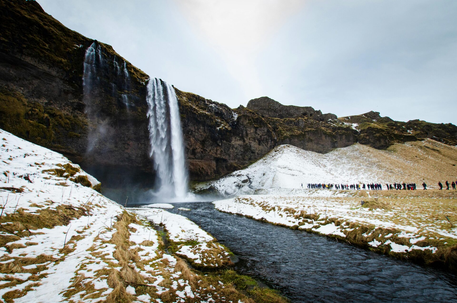
Seljalandsfoss
A waterfall that falls from a cliff overhang, leaving a narrow path behind it. You can walk the full 180 degrees around the back of the falls — wet gear is not optional, the spray soaks everything within 20 metres. In summer, the falls are lit by midnight sun in a quality of light that turns the water gold. In winter, ice formations appear on the rock face behind the falls. Free entry; parking fee £5.
Gljúfrabúi — 200 metres further along the path — is a hidden falls enclosed inside a slot canyon. You wade through a shallow stream to reach it. Almost nobody goes because there’s no sign for it and the entrance looks like a rock. Go.
Skógafoss
Bigger than Seljalandsfoss — 60 metres high, 25 metres wide. A staircase climbs to the clifftop above for the view down the glacial valley. In winter: ice columns on the cliffs beside the falls, sometimes frozen entirely. In summer: rainbows in the spray by 9am every clear morning. Free entry.
The Fimmvörðuháls trail begins here — the first section of the Laugavegur trail, passing between Eyjafjallajökull and Mýrdalsjökull glaciers, crossing the Magni and Móði lava fields from the 2010 eruption, reaching Þórsmörk valley. It’s a full day (22km, 7–9 hours) and requires good fitness and weather. One of the finest hikes in Iceland.
Reynisfjara Black Sand Beach
Black volcanic sand, hexagonal basalt columns stacked like bundles of pencils, and North Atlantic waves that arrive with no warning from behind you.
The warning sign at the entrance is serious: sneaker waves — waves that surge further up the beach than the preceding pattern suggests — have killed people here. Do not turn your back on the water. Do not sit near the waterline. Do not let children near the waterline. The waves are beautiful and they are genuinely dangerous. The beach is free and open all hours.
The basalt columns (Reynisdrangar) rising from the sea offshore, the black cave in the cliff face to the east, and the whole visual composition of the beach are extraordinary. It’s one of the most dramatic beaches on Earth and it requires a specific kind of respect.
Jökulsárlón Glacier Lagoon
Icebergs calved from Vatnajökull — Europe’s largest glacier — float through the lagoon toward the sea, some the size of houses, some the size of buildings. The colour of the ice ranges from white to blue to black (the black comes from volcanic ash trapped in the ice from historical eruptions). The lagoon sits directly beside Route 1.
The boat tour through the icebergs (£40, 45 minutes in summer, amphibious boat) is one of the best-value experiences in Iceland — you’re in among the ice, close enough to hear it creak and occasionally crack. In winter: the boat doesn’t run, but the icebergs are larger and the light is different and the lagoon feels more desolate and more extraordinary.
Diamond Beach
On the opposite side of the road from the lagoon: the black sand beach where icebergs, washed out to sea and back, sit among the volcanic sand. The contrast — translucent blue ice on black sand, Atlantic waves crashing behind — is one of the most photographed scenes in Iceland. The icebergs are there year-round. The best light is early morning or evening.
The Ring Road — What It Actually Involves
The Ring Road (Route 1) circumnavigates Iceland — 1,332km, connecting all major regions. It’s the definitive Iceland road trip and significantly more involved than most guides suggest.
The time reality: Most internet sources say “the Ring Road takes 7–10 days.” The more accurate version: 10–12 days done at a pace that allows you to actually be in the places rather than just drive through them. At 7 days, you’re driving 4–6 hours a day with limited time at each stop. At 10 days, the drive days shorten to 2–3 hours and the stops expand to actual experiences.
The seasonal reality: Parts of the Ring Road — particularly the north and east — are significantly less dramatic than the south coast and the Snæfellsnes Peninsula. The east (Eastfjords) is the most remote, least visited, and most authentically Icelandic section — small fishing villages, dramatic fjords, virtually no other tourists. It is not visually spectacular in the same way as the south. Understanding that before you go sets the right expectations.
The highlights by region:
North Iceland: Lake Mývatn (a geothermal lake with pseudo-craters, lava formations, and the best birdwatching in Iceland), Goðafoss waterfall (one of the finest in the country), Húsavík (whale watching capital of Iceland — higher success rates than Reykjavik, more intimate boats, humpback whales common), Ásbyrgi canyon (a horseshoe-shaped canyon that Norse mythology said was formed by the hoof of Odin’s horse).
East Iceland: The Eastfjords — a series of deep glacially-carved fjords with fishing villages at the end of each one. Egilsstaðir is the main service town. The region has the lowest tourist footfall on the Ring Road. The puffin colony at Borgarfjörður eystri is one of the most accessible in Iceland.
Snæfellsnes: A peninsula 2 hours from Reykjavik that contains, in miniature, almost everything Iceland has to offer. The Snæfellsjökull glacier (the one Jules Verne sent his characters into the centre of the Earth through). The church at Búðir. The lava fields. Kirkjufell mountain — the most photographed mountain in Iceland. Worth a 2-day detour from any itinerary.
The Snæfellsnes Peninsula — The Underrated Alternative
If the Ring Road is too ambitious for your timeframe, the Snæfellsnes Peninsula is the best alternative structure for a 5–7 day Iceland trip. It’s 2 hours from Reykjavik, covers most of what Iceland offers, and can be done on a loop without requiring the full Ring Road commitment.
Kirkjufell — a distinctive arrowhead-shaped mountain on the north coast of the peninsula, with two waterfalls (Kirkjufellsfoss) in front of it. The most photographed mountain in Iceland, used as a Game of Thrones filming location. The view from the car park below is the iconic one; the hike to the summit is serious (steep, rope-assisted sections) and requires experience. The waterfalls freeze in winter in a way that creates a different image entirely.
Snæfellsjökull National Park — at the tip of the peninsula, a glacier-capped volcano and the park around it: lava tubes (Vatnshellir cave), sea cliffs with nesting birds, the remains of fishing villages, and black sand beaches with a completely different character to the south coast.
Arnarstapi and Hellnar — two small fishing villages on the south coast of the peninsula connected by a 2.5km coastal walk through lava formations and sea arches. The walk takes 45 minutes. One of the finest short walks in Iceland.
Búðir — a black church on a lava field beside a lagoon, with the glacier visible on the horizon. Genuinely one of the most beautiful compositions of landscape and human structure in the country.
The Westfjords — For the Serious Traveller
The Westfjords are the most dramatic and least visited region in Iceland. A thumb of land in the northwest, cut by deep fjords, with no Ring Road connection (the Westfjords have their own road system that branches off the Ring Road in the west). To reach them requires either driving northwest from Reykjavik (3 hours to the start of the region) or flying to Ísafjörður on Air Iceland Connect (45 minutes, from £80 one way).
What you get for the difficulty: the Látrabjarg bird cliffs — the largest seabird colony in Iceland, 14km long, 440m high, with puffins nesting close enough to touch (don’t touch them) from late May through August. The Dynjandi waterfall — a 100m wide fan of falling water, descending in seven steps, accessible by a 1km walk from the road. The Hornstrandir nature reserve — the most remote and most beautiful hiking in Iceland, accessible only by boat from Ísafjörður, with no services and no permanent inhabitants.
The Westfjords are for travellers who have at least 10 days in Iceland and have done the south coast and the Golden Circle on a previous trip. Or for travellers who specifically want to be somewhere genuinely remote.
The Highland Interior — The Iceland Nobody Shows You
The highland interior is 40,000 square kilometres of uninhabited volcanic plateau in the centre of Iceland. It looks more alien than anything on the Ring Road. Almost nobody goes.
The access reality: The highland F-roads require a 4WD with high clearance — not an all-wheel-drive SUV, an actual off-road vehicle with river-crossing clearance. Most standard Landcruisers and large SUVs from rental companies qualify. Hatchbacks, saloon cars, and most standard crossovers do not. The rental companies are serious about this — driving a standard car on an F-road voids your insurance and has resulted in expensive rescues. The F-roads are open July to mid-October, depending on the year’s snowfall.
Landmannalaugar
The entry point for the highland interior and the start of the Laugavegur Trail. A geothermal camping and hiking area in the Fjallabak Nature Reserve — the landscape is rhyolite mountains in red, yellow, orange, green, and purple, coloured by mineral deposits in the volcanic rock. A natural hot spring sits in the middle of the campsite, always at around 38°C, surrounded by snow-dusted peaks. The colour of the mountains at any time of day is extraordinary; at evening golden hour it becomes unreasonable.
Getting to Landmannalaugar: F-road from Reykjavik (4WD only, 3–4 hours), or the highland bus from BSÍ terminal in Reykjavik (£40 return, bookable at re.is — runs July to mid-September, takes 4 hours, no 4WD required).
The Laugavegur Trail
55km from Landmannalaugar to Þórsmörk. Four to five days of hiking. The landscape shifts completely every half-day: rhyolite mountains, obsidian lava fields, glacial rivers (ford crossings without bridges — cold, knee-deep, unavoidable), ash plains, green valley forests. Huts at each overnight stop (book months ahead — they fill completely). Rated among the finest multi-day hikes in the world by everyone who has done it.
Kerlingarfjöll
A geothermal mountain range accessible via the Kjölur highland road (F35) — more accessible than Landmannalaugar (large 4WDs can make it in better conditions). Steam vents on the hillsides, orange and yellow mineral deposits, snow-covered peaks in September. The hot river at Hveradalir — a natural geothermal stream at 40°C flowing through a valley of steaming rock — is one of the most extraordinary natural experiences in Iceland. You can sit in it while the surrounding mountains steam around you.
Why Most People Miss the Interior
The Golden Circle and South Coast are accessible in a standard car. They’re well-signed. They’re covered by every tour bus company in Reykjavik. The interior requires a 4WD, forward planning, and the willingness to drive roads that occasionally involve river crossings.
This is exactly why it’s worth going. The landscapes that are difficult to reach are the ones that haven’t been optimised for tourism. The Landmannalaugar hot spring at 7am, with three other people and the mountains turning orange in the early light, is the version of Iceland that makes people describe it as life-changing.
The Northern Lights — The Honest Guide
The Northern Lights are the single most-searched Iceland experience and the one most vulnerable to unrealistic expectations. Here’s the honest version.
What they are: The aurora borealis — charged particles from the sun interacting with the Earth’s magnetic field, creating curtains and waves of light across the upper atmosphere. They appear in shades of green (most common), pink, purple, and occasionally red. They move. They pulse. They appear and disappear in seconds.
When they appear: September to March (you need darkness — in summer Iceland it never gets dark enough). The highest activity windows are around the equinoxes (September and March). The strongest aurora events correlate with solar activity, which follows an 11-year cycle — the current cycle is approaching solar maximum, meaning aurora activity is at its most intense in years.
What they require: A clear sky. No cloud cover means no Northern Lights visible regardless of aurora activity. Iceland’s weather is notoriously changeable — checking the aurora forecast (vedur.is gives both cloud cover and aurora strength on the same page) is essential but doesn’t guarantee a clear night.
The Aurora forecast: The Icelandic Met Office (vedur.is) shows the aurora strength on a scale of 0–9 (0 is minimal, 9 is extreme) and the cloud cover forecast. You want: aurora strength 3+ and cloud cover less than 30% in your area. On a night with strength 5+ and clear skies, the aurora is visible to the naked eye and photogenic. On a night with strength 1 and heavy cloud, you’ll see nothing.
Best locations:
- South coast guesthouses, away from Reykjavik light pollution (the most reliable base)
- Þingvellir National Park (dark skies, 45 minutes from Reykjavik)
- The Snæfellsnes Peninsula
- North Iceland in winter (darker for longer, but requires more travel)
Reykjavik itself has light pollution that washes out all but the strongest displays. Drive 30 minutes from the city minimum.
The honest expectation: On a 5-night winter Iceland trip with one clear night, you have a reasonable chance of a Northern Lights sighting. On a 5-night trip with cloudy nights throughout, you may see nothing regardless of aurora strength. This is weather. Plan around flexibility — a 7-night trip gives better odds than a 4-night trip.
The photography reality: The aurora photographs much more dramatically than it appears to the naked eye. Long-exposure camera shots (10–20 seconds) capture colours and intensity that the eye sees only partially. The photo on your friend’s Instagram from Iceland is not lying — it’s showing what a camera sees on a long exposure. The experience to the naked eye is subtler, more ephemeral, and in many ways more affecting.
What It Costs — The Honest Numbers
Iceland is expensive. There’s no version of this guide that pretends otherwise. It’s the most expensive country in Europe for food and accommodation and the gap between Iceland and its nearest competitor is significant.
Why it costs what it costs: Iceland is a remote North Atlantic island with a small population, significant import costs, and a quality of service that reflects a high-wage economy. Supermarket food costs roughly 50% more than the UK. Restaurant food costs 80–120% more. Accommodation is priced at European resort rates in the major tourist areas.
The strategies that actually reduce costs:
Supermarket self-catering for breakfast and lunch every day. Kronan and Bonus (the yellow pig sign) are the cheapest supermarket chains. A substantial breakfast and a packed lunch from a supermarket costs £8–12/day for two people. Eat one restaurant meal in the evening.
Camping reduces accommodation costs dramatically. Iceland has an extensive network of established campsites (£12–18/person/night) and wild camping is permitted on public land with standard leave-no-trace rules. In summer, a tent and a camping pass covers the whole country. In winter, camping is cold and most campsite facilities close.
Airbnb in Reykjavik versus city hotels: a significant price difference exists, and apartments allow self-catering which compounds the saving.
Daily Budgets
Budget (£80–110/day, self-catering)
- Accommodation: hostel dorm or camping (£15–25/person)
- Food: supermarket breakfast and lunch, one meal out (£20–30)
- Petrol: £20–30 (assuming 200km/day)
- Activities: most outdoor sites free
Mid-range (£140–190/day, mix of guesthouse and self-catering)
- Accommodation: guesthouse/hotel (£70–110/night for a room)
- Food: supermarket breakfast, one sit-down lunch, one restaurant dinner (£35–50)
- Petrol: £20–30
- One paid activity (boat tour, ice cave tour, etc): £40–80
Comfortable (£220–300/day)
- Boutique hotel or farm stay: £120–200/night
- All restaurant meals: £60–90/day
- Activities without budget concern
What 7 Days in Iceland Actually Costs from the UK
| Category | Budget | Mid-Range |
|---|---|---|
| Return flights (3 months ahead) | £80–150 | £120–200 |
| Car hire (7 days, standard 4WD) | £280–420 | £350–550 |
| 7 nights accommodation | £180–280 | £490–700 |
| Food (7 days, mix of self-catering and dining) | £180–280 | £280–400 |
| Petrol (7 days Ring Road section) | £140–180 | £140–180 |
| Activities (Blue Lagoon / boat tour / ice cave) | £80–150 | £120–250 |
| Total | £940–1,460 | £1,500–2,280 |
The car hire figure is the most variable. A standard 2WD hatchback (fine for Ring Road and South Coast in summer) costs £200–300/week. A 4WD for highland access costs £350–500/week. A super-jeep for serious F-road driving costs £600–900/week.
Driving in Iceland — What You Need to Know
You must drive in Iceland. There is no public transport equivalent to the hire car network for covering the distances involved. Organised tours from Reykjavik cover the Golden Circle and South Coast, but the Ring Road and the interior require a car.
The car you need:
- Ring Road and South Coast in summer: any car, including a standard hatchback
- Ring Road and South Coast in winter: a larger car with good ground clearance (ice and occasional snow on the road)
- Snæfellsnes Peninsula: standard car in summer, larger in winter
- Highland F-roads: 4WD with high clearance, full stop. Rental companies check this and voids insurance if violated.
The road conditions app: Download the Vegagerdin app (Icelandic Road Administration) before you arrive. It shows real-time road conditions, closures, and weather on every road in the country. Check it every morning before driving. Roads that were open yesterday can be closed by 9am today.
Speed limits: 90km/h on paved roads, 80km/h on gravel, 30–50km/h in towns. Speed cameras throughout Iceland. Fines are significant.
Single-lane bridges: Common on the Ring Road and secondary roads. One car crosses at a time. The approaching car that is furthest from the bridge gives way. This requires judgment — look far ahead and reduce speed approaching any single-lane bridge.
Gravel roads: A significant portion of Route 1 in the east and north is gravel. Slow down (60–70km/h maximum on gravel). Gravel at speed damages the car and the windscreen — damage that rental insurance typically covers poorly. Keep your distance from oncoming vehicles and slow down when they pass.
Practical Notes
Visa: UK passport holders receive a 90-day visa exemption under the Schengen Area agreement. No visa required, no application.
Getting there: Direct flights from London Heathrow, Gatwick, Stansted, Edinburgh, Manchester, and several other UK airports. Icelandair, easyJet, Wizz Air. Flight time: 2h 45m to 3h 15m depending on departure airport. Keflavik Airport is 50km southwest of Reykjavik — the Flybus (airport bus) connects to the BSÍ terminal in Reykjavik in 45 minutes (£18 one way). Hire cars are collected at the airport car rental desks.
Currency: Icelandic Króna (ISK). £1 ≈ 175 ISK at time of writing. Iceland is effectively cashless — cards accepted everywhere including parking meters, remote guesthouses, and campsite gates. Carry £50 equivalent in cash for genuine emergencies, otherwise use card.
Petrol: Fuel in Iceland is significantly more expensive than the UK (roughly 30–40% more per litre). Fill up at every opportunity in the east and north — service stations are sparse and some F-road crossings require fuel planning in advance. The N1 app shows petrol station locations and current prices across the country.
Getting a SIM: Siminn and Nova both offer tourist SIMs at Keflavik Airport. A 30-day SIM with 15–30GB data costs £20–30. Data coverage is good on the Ring Road and most major routes; expect gaps in the Westfjords and some F-road sections. Alternatively, Airalo eSIMs work on Icelandic networks.
Weather: Plan for all conditions every day, regardless of the forecast. Rain, sun, snow, wind, fog — sometimes in the same hour. Layering is the only clothing strategy. A waterproof outer layer and warm mid-layer are essential year-round. In winter, add thermal base layers and proper gloves.
The midnight sun: In June and July, the sun doesn’t set. This is magnificent. It also means your body has no natural sleep cues. Blackout curtains in accommodation are standard. Bring an eye mask regardless.
The 7-Day Road Trip — The Route That Works
This itinerary covers the Golden Circle, the South Coast, the Snæfellsnes Peninsula, and enough of the Ring Road north to give the full picture of Iceland without the time commitment of the full circuit.
Day 1: Reykjavik Land at Keflavik. Collect hire car. Into Reykjavik by early afternoon. Hallgrímskirkja tower. Walk Laugavegur. Dinner in the city. Sleep.
Day 2: Golden Circle Þingvellir (2 hours) → Geysir (1 hour) → Gullfoss (1 hour) → Kerið crater (30 minutes) → return to Reykjavik or overnight at a guesthouse near Selfoss. Distance: 230km, 5–6 driving hours including stops.
Day 3: South Coast to Vik Seljalandsfoss (including Gljúfrabúi) → Skógafoss → Reynisfjara black sand beach → Vik village overnight. The most spectacular driving day of the trip. Distance: 180km, 4–5 hours including stops.
Day 4: South Coast to Jökulsárlón Fjaðrárgljúfur canyon (30 minutes off the main road — an extraordinary slot canyon that rewards the detour) → Jökulsárlón Glacier Lagoon → Diamond Beach → overnight at a farm guesthouse near the lagoon. Distance: 200km, 4–5 hours.
Day 5: Return west, Snæfellsnes turnoff Drive back along the Ring Road toward Reykjavik (or take the southern highland route via Þórsmörk if conditions allow) → north on Route 54 to the Snæfellsnes Peninsula → overnight in Grundarfjörður or Stykkishólmur. Distance: 280km, 5–6 hours.
Day 6: Snæfellsnes Peninsula Kirkjufell → Snæfellsjökull National Park (Vatnshellir cave, Djúpalónssandur beach) → Arnarstapi coastal walk → Búðir church → drive south back toward Reykjavik → overnight near Borgarnes or back in Reykjavik. Distance: 200km, 5 hours.
Day 7: Reykjavik and Keflavik Morning in Reykjavik. National Museum or Settlement Exhibition. Lunch. Keflavik Airport for evening flight home.
Total cost estimate:
| Category | Mid-Range |
|---|---|
| Return flights | £120–200 |
| Car hire (7 days, 2WD summer / 4WD winter) | £280–420 |
| 7 nights accommodation | £490–700 |
| Food (self-catering mornings, one meal out daily) | £210–280 |
| Petrol | £140–180 |
| Activities (1 boat tour or ice cave, Þingvellir entry) | £80–120 |
| Total | £1,320–1,900 |
Final Though
There’s a specific quality of light in Iceland in September — low, coming from the south at a shallow angle, turning the lava fields from black to deep red-brown and the glaciers from white to gold — that I’ve never seen duplicated anywhere else.
I was driving east on Route 1 somewhere between Vík and Jökulsárlón, the road crossing a lava plain with a glacier visible to the north and the Atlantic to the south, and the light was doing that thing. I pulled over.
You can’t plan for that. You can only put yourself on the road.