
The treks worth doing, done properly — with the permit logistics, the day-by-day breakdown, the teahouse contacts, the altitude warnings, and the specific moments that make each route more than a fitness exercise.
Everest Base Camp — Day by Day
12 days. 5,364 metres. The most famous trek in the world. Here’s what each day actually looks like.
The Overview
Total distance: 130km return from Lukla Maximum altitude: 5,364m (Base Camp) / 5,545m (Kala Patthar optional) Duration: 12-14 days (including acclimatisation days) Best season: March-May (spring) and October-November (autumn) Avoid: June-August (monsoon), December-February (cold, trail icy above 4,000m) Permit costs: Sagarmatha National Park permit (NPR 3,000 / £18.94) + TIMS card (NPR 2,000 / £12.62) Teahouse cost: £3-10/night dormitory, £5-18/night private room (prices rise with altitude) Dal bhat: £3-6 (unlimited refills — the correct trekking fuel) Guide: Optional on the main EBC route. Recommended above Dingboche (4,410m) for safety and navigation in poor visibility. Cost: £22-32/day. Porter: Strongly recommended. Cost: £12-18/day. The correct hire.
The Lukla Flight
The most important logistical fact about EBC: the flight from Kathmandu to Lukla (Tenzing-Hillary Airport, the world’s most dangerous airport by most assessments — 9,337 feet of elevation, a 12% gradient runway, mountains on three sides) is weather-dependent. Cancellation rate: 15-25% depending on season.
Build 2-3 buffer days into the Kathmandu end of the trip. This is the single most important EBC planning instruction. Travellers who don’t build buffer and the Lukla flight cancels miss the trek or pay for emergency helicopter transport to Lukla (approximately £250-350 one way).
Departure point: Kathmandu Tribhuvan Airport, Terminal 2. Check in 1.5 hours early. Flight duration: 35-45 minutes. Cost: approximately £130-180 return (book through Tara Air or Summit Air in Kathmandu).
Day by Day
Day 1: Lukla (2,860m) → Phakding (2,652m) Distance: 8km | Time: 3 hours
The trail descends from Lukla into the Dudh Koshi River valley — the first Sherpa villages, the mani stones (carved with the Buddhist mantra Om Mani Padme Hum, always passed on the left), the suspension bridges over the river. The descent from Lukla means Day 1 is the easiest day physically. Phakding is a small village of teahouses: stay here, eat dal bhat, sleep early.
Teahouse to note: Himalayan Lodge (the most consistently recommended in Phakding for cleanliness and food quality).
Day 2: Phakding (2,652m) → Namche Bazaar (3,440m) Distance: 11km | Time: 5-6 hours
The first significant ascent — the trail climbs 800m through a series of suspension bridges over the Dudh Koshi, the final approach to Namche via the steep staircase from the river. The first view of Everest: from the trail above the river before the final Namche ascent (the mountain visible above the Lhotse-Nuptse ridge, the South Summit and the main summit triangle). This is the first sighting. Note it.
The Hillary Bridge: The highest suspension bridge on the EBC trail (160m above the river) — the crossing is memorable. The bridge is high-maintenance and the planks occasionally need attention; it is structurally sound.
Namche Bazaar: The largest town on the EBC route — a horseshoe of teahouses, trekking shops, bakeries (the Namche Bakery is genuinely good: fresh bread, coffee, cinnamon rolls at altitude), a Saturday market. The Everest View Hotel above the town: a short hike gives the finest panorama of the Everest-Lhotse-Ama Dablam massif available without going higher.
Day 3: Namche Bazaar — ACCLIMATISATION DAY Rest day. Non-negotiable.
The 2-night stay in Namche (arriving Day 2 evening, departing Day 4 morning) is the most important acclimatisation decision on the EBC trek. Ascending from 2,652m (Phakding) to 3,440m (Namche) in one day without a rest produces altitude sickness in a significant proportion of trekkers who skip the Namche acclimatisation. The standard rule: sleep no more than 300-500m higher than the previous night, and rest every third day.
Day 3 activity: The hike from Namche to Everest View Hotel (3,880m) and back — a 3-4 hour loop that acclimatises through movement without altitude gain from the sleeping altitude. The panorama from the hotel: Everest, Lhotse, Nuptse, Ama Dablam, Thamserku. One of the finest single views in Nepal.
Altitude sickness symptoms to watch: Headache (the most common), nausea, dizziness, loss of appetite, poor sleep. Mild symptoms: rest and hydrate. If symptoms worsen or you develop the Diamox prescription, follow the medical guidance. If symptoms include confusion, loss of coordination, or cough with pink froth (pulmonary oedema): descend immediately.
Day 4: Namche Bazaar (3,440m) → Tengboche (3,867m) Distance: 10km | Time: 5-6 hours
The trail above Namche gives the full Everest panorama — the mountain visible for much of the first hour of walking. The path traverses the hillside above the Dudh Koshi valley (the valley of the river visible far below), passes the Everest photo viewpoint, and descends into the Tengboche Valley before the final ascent.
Tengboche Monastery: The most significant Buddhist monastery in the Khumbu Valley — the rebuilt monastery (the original burned in a 1989 fire, the current structure opened in 1993) is the largest in the region and the location of the Mani Rimdu festival (the three-day masked dance festival, typically held in October or November — if the timing aligns, attend). The evening prayer session (6pm): the monks in the prayer hall, the horns, the drums, the chanting.
Day 5: Tengboche (3,867m) → Dingboche (4,410m) Distance: 14km | Time: 5-7 hours
The trail descends through the rhododendron forest (late March-April: in flower, the slopes pink and red) to the Imja Khola river and ascends through the increasingly sparse vegetation to Dingboche. Above 4,000m the vegetation changes dramatically — the rhododendron forest gives way to dwarf juniper and open alpine terrain. The scale of the mountains increases.
Dingboche is the last settlement before the high altitude begins in earnest. Sleep well.
Day 6: Dingboche (4,410m) — ACCLIMATISATION DAY
The second mandatory rest day. The hike option: up the ridge above Dingboche to 4,800-5,000m (4-5 hours return) — the Ama Dablam massif directly ahead, Makalu (the fifth-highest peak on Earth) visible to the east. The altitude gain gives the body the stimulus to produce additional red blood cells; the return to the 4,410m sleeping altitude gives the recovery.
Day 7: Dingboche (4,410m) → Lobuche (4,910m) Distance: 8km | Time: 4-5 hours
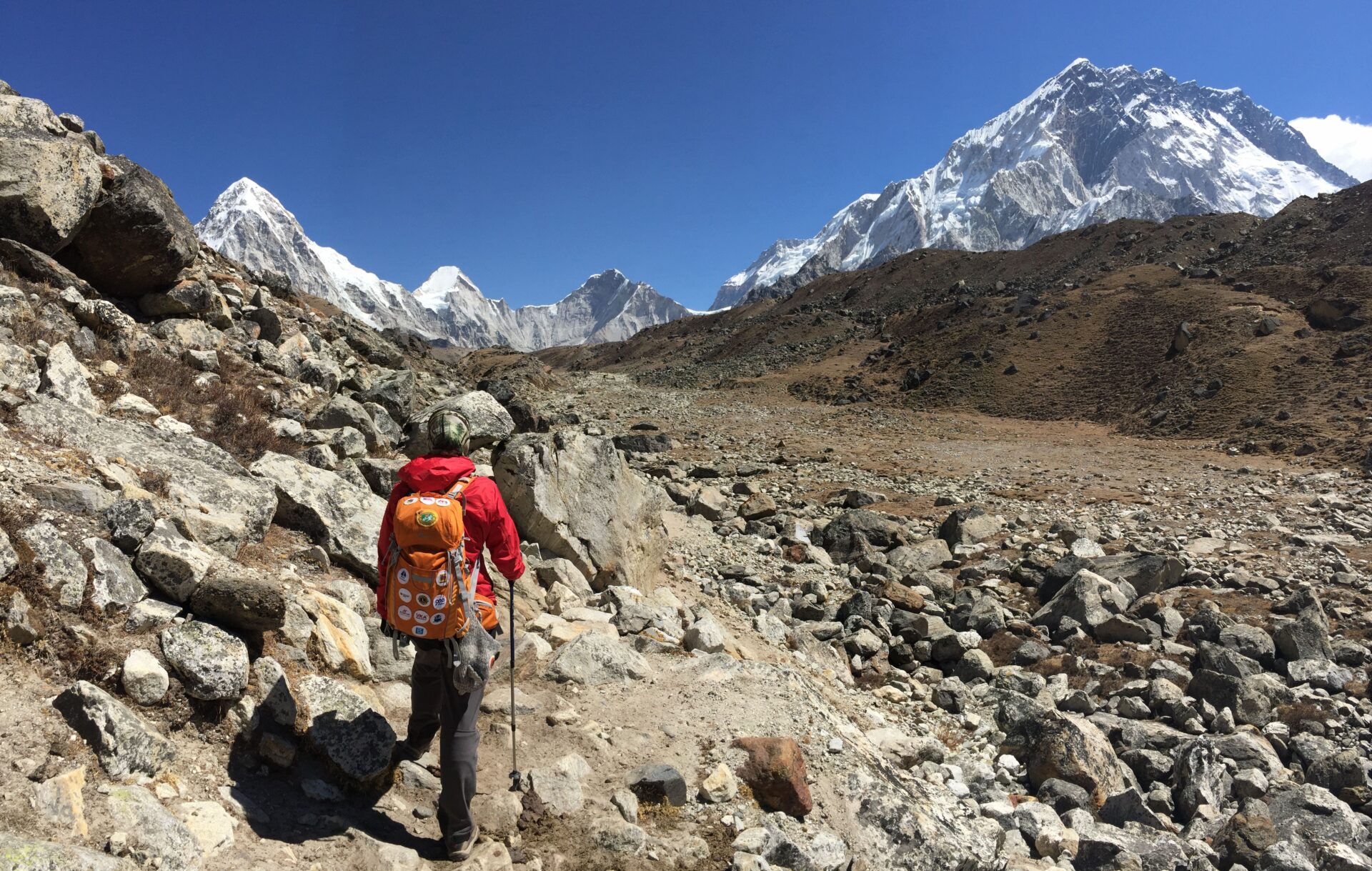
The trail passes the Thukla memorial (the cluster of memorials to Sherpa and climbers who have died on Everest — the memorial stones for Rob Hall, Scott Fischer, and others who died in the 1996 season described in Jon Krakauer’s Into Thin Air are here). The climb above Thukla to the Khumbu Glacier moraine is the first challenging terrain — loose rocks on the moraine, the altitude making the breathing difficult.
Lobuche: a collection of teahouses at the edge of the Khumbu Glacier moraine. Cold. The wind can be significant. The teahouses are warm. Dal bhat, sleep.
Day 8: Lobuche (4,910m) → Gorak Shep (5,140m) → Everest Base Camp (5,364m) → Gorak Shep Distance: 14km | Time: 8-9 hours
The summit day. Depart Lobuche at 6am.
Gorak Shep (the last settlement before Base Camp): 2 hours from Lobuche. Leave bags at the teahouse (the EBC hike is a return to Gorak Shep for the night). Walk the final section to Base Camp.
Everest Base Camp itself: In the trekking season (March-May), the Base Camp is an active expeditionary community — the yellow and orange tents of the climbing teams visible on the glacier, the fixed ropes visible on the Khumbu Icefall above. In the autumn trekking season (October-November), the climbers have left and the site is quieter.
The specific moment: standing at the end of the glacier moraine, the Khumbu Icefall above, the prayer flags. Everest itself is not visible from Base Camp (the mountain is obscured by the Nuptse ridge). The closest view of the summit: from the Kala Patthar ridge.
Return to Gorak Shep. Altitude: 5,140m. Sleep. Drink water. Eat.
Day 9 (optional): Gorak Shep (5,140m) → Kala Patthar (5,545m) → Gorak Shep → Pheriche (4,371m)
The Kala Patthar dawn: depart Gorak Shep at 4:30am, summit by sunrise (approximately 5:45am in October). The view: Everest above the Nuptse ridge, the South Col, the summit pyramid in the dawn light. The finest accessible view of Everest’s summit available to trekkers. 405m above Gorak Shep.
After Kala Patthar: descend to Pheriche (or Dingboche) in the same day — the descent is fast and the body benefits from dropping altitude.
Days 10-12: Descent to Lukla
The descent covers in 3 days the distance that took 7-8 days to ascend. The trail is familiar; the body is stronger; the altitude effects diminish with every 100m of descent.
Day 10: Pheriche → Namche Bazaar (1 long day, or 2 shorter days via Tengboche) Day 11: Namche Bazaar → Lukla (full day, 19km) Day 12: Lukla → Kathmandu (flight, weather permitting)
The Kit List
| Item | Notes |
|---|---|
| Down jacket (-20°C rated) | Essential above 4,000m, available to hire in Kathmandu/Namche (£3-5/day) |
| Trekking boots (ankle support, waterproof) | Worn in before the trek — blisters at altitude are serious |
| Trekking poles | Particularly useful for the descent; available to hire |
| Sleeping bag (-15°C rated) | Teahouses provide blankets but sleeping bags at altitude are warmer |
| Water purification (tablets or Steripen) | Teahouses provide boiled water; purification for stream water |
| Altitude medication (Diamox) | Consult a travel clinic before Nepal; requires prescription |
| Head torch | Essential — teahouse electricity is limited |
| Sunscreen + lip balm | UV at altitude is significantly stronger than at sea level |
The Inca Trail — Permits and Preparation
The 4-day guided trek to Machu Picchu. The world’s most famous and most permit-constrained trek.
The Permit Reality
The Inca Trail permits are allocated in strict daily quotas: 500 permits per day total (200 for trekkers, 300 for guides and porters). All permits are sold through licensed Peruvian tour operators — there is no independent access to the Inca Trail.
Permits sell out. The June-August and the September-October windows sell out months in advance — some operators’ allocations for July are gone by January. Book 5-6 months ahead for peak season. Book 3-4 months ahead for shoulder season.
Booking process:
- Choose a licensed operator from the list approved by the Peruvian Ministry of Culture (search: “Inca Trail licensed operators 2025”)
- Confirm the trekking dates and the number of people
- Provide full passport details (the permit is passport-specific — losing your passport means losing your Inca Trail permit)
- Pay the full amount (permits are non-refundable and non-transferable)
Permit cost (included in operator price): $630+ / £496+ per person including the permit, guide, cook, and porters. The total operator cost including food and camping equipment: approximately £700-900/person for the 4-day trek.
Day by Day
Day 1: Km 82 (2,600m) → Huayllabamba (3,000m) Distance: 12km | Time: 5-6 hours
The start: Km 82 on the rail line from Cusco to Aguas Calientes — the train drops groups here, the groups walk the first section through the Sacred Valley, the Urubamba River below, the Inca agricultural terraces visible on the valley sides.
The first Inca ruins: Patallacta (the “Town above the terraces”) — a large Inca administrative and agricultural complex visible across the valley from the trail. The first substantial archaeological site on the trail.
Huayllabamba is the last permanent village on the trail — the last opportunity to buy snacks (bring your own supply).
Day 2: Huayllabamba (3,000m) → Pacaymayo camp (3,600m) — DEAD WOMAN’S PASS (4,215m) Distance: 12km | Time: 8-9 hours
The hardest day. Dead Woman’s Pass (Warmihuañusca in Quechua) is the highest point on the Inca Trail — named for the profile of the ridge against the sky, which resembles a supine figure. The ascent from the camp to the pass is 1,215m over approximately 6km — steep, the altitude making every step a negotiation with the lungs.
From the pass: the descent to Pacaymayo camp through the cloud forest. The descent is faster but requires concentration on the uneven Inca stone steps.
The cloud forest from Day 2 onward: the specific ecosystem of the Andean cloud forest — the orchids (300+ species recorded on the Inca Trail), the hummingbirds, the bromeliads, the specific green of a forest that exists in cloud 200 days a year.
Day 3: Pacaymayo (3,600m) → Wiñay Wayna (2,650m) — TWO MORE PASSES Distance: 16km | Time: 8-9 hours
The finest trail day — two passes (Runkurakay, 3,950m, and Phuyupatamarca, 3,600m), the longest archaeological section of the trail, and the descent to the finest Inca site accessible only by the Inca Trail.
Wiñay Wayna (“Forever Young” in Quechua — named for the orchid that grows in the site’s stonework): a mid-15th-century Inca site of terraced fountains and dwelling structures, 2,650m above sea level, the cloud forest surrounding it, the Urubamba River 400m below visible through the cloud. The camp is adjacent to the site — waking at 5am and walking through the empty Wiñay Wayna ruins before the groups from earlier camps arrive is the finest morning on the Inca Trail.
Day 4: Wiñay Wayna → Sun Gate (2,720m) → Machu Picchu (2,430m) Distance: 8km | Time: 3-4 hours
The 5:30am departure from Wiñay Wayna — the guided groups queue at the checkpoint in darkness and are released in groups of 25 at intervals. The final 90-minute walk to the Sun Gate (Inti Punku) — the original Inca entrance to Machu Picchu, the point from which the city is first visible.
The Sun Gate at dawn: Machu Picchu below, the Huayna Picchu mountain behind it, the cloud in the valley below the site, the first light from the east. This is why the permit cost is what it is. This is the moment that no photograph adequately represents.
The Alternatives to the Inca Trail
If permits are sold out or the budget doesn’t extend to the full Inca Trail:
Salkantay Trek (5 days, £300-450): The most spectacular alternative — crosses the Salkantay Pass (4,638m, higher than the Inca Trail’s highest point) with views of the Salkantay Glacier, descends through the cloud forest to the coffee and cacao zone, arrives at Aguas Calientes by bus or train. No permit required.
Lares Trek (3 days, £200-300): The cultural alternative — through the Lares Valley, the Quechua-speaking communities, the hot springs. Arrives at Ollantaytambo by road, train to Aguas Calientes.
Train to Aguas Calientes (PeruRail, £65-90 return): The non-trekking option. The train journey through the Sacred Valley and the gorge is excellent. The Machu Picchu visit from Aguas Calientes gives the same site with none of the Sun Gate approach.
Poon Hill — The 4-Day Himalayan Trek
The most accessible significant Himalayan viewpoint in Nepal. The Annapurna Range panorama at dawn from 3,210m.
Why Poon Hill
Poon Hill is the entry-level high-altitude trek — 4 days, 60km total, maximum altitude 3,210m (below the acclimatisation-critical 3,500m threshold for most trekkers). The dawn panorama from the Poon Hill viewpoint: the Annapurna Range (Annapurna I at 8,091m, Annapurna South, Hiunchuli, Machhapuchhre) in the first light, the specific quality of the Himalayan peaks turning gold before the sun reaches the valley.
The trek is the correct introduction to Himalayan trekking for first-time Nepal visitors and serves as the standalone highlight for visitors with limited time (4 days from Pokhara, back in Pokhara on Day 5).
Permits: TIMS card (NPR 2,000 / £12.62) + Annapurna Conservation Area Permit (ACAP, NPR 3,000 / £18.94). Starting point: Nayapul (1.5 hours from Pokhara by bus, NPR 200 / £1.26).
Day by Day
Day 1: Nayapul (1,070m) → Tikhedhunga (1,540m) Distance: 14km | Time: 4-5 hours
The trail follows the Modi Khola river through subtropical vegetation — the warmest day of the trek. Tikhedhunga is a small village with guesthouses and restaurants. Early night.
Day 2: Tikhedhunga (1,540m) → Ghorepani (2,860m) Distance: 12km | Time: 5-6 hours
The significant ascent — 3,300 stone steps from the valley to the ridge (the famous Tikhedhunga stone stairs, the most discussed section of the Poon Hill trek), then through rhododendron forest (flowering in March-April: the forest a tunnel of pink and red) to Ghorepani. The views of the Annapurna Range begin from the ridge sections.
Ghorepani is the main settlement and the trail hub — the guesthouses are better equipped than elsewhere on the trek. The 3am alarm for the morning ascent to Poon Hill is set here.
Day 3: Ghorepani → Poon Hill at dawn → Tadapani (2,630m)
4am: the head torches on the trail from Ghorepani to Poon Hill (45 minutes, 350m ascent). The queue of trekkers at the viewpoint tower at 5am. The sun rising behind Dhaulagiri (8,167m) at approximately 6am in October. The Annapurna Range from Annapurna South to Annapurna II illuminated across the full arc. The specific ten minutes of alpenglow on the snow before the light becomes ordinary.
After Poon Hill: return to Ghorepani for breakfast, then continue to Tadapani through the forest. The rhododendron forest between Ghorepani and Tadapani: the finest section of the high-altitude forest on the trek.
Day 4: Tadapani (2,630m) → Ghandruk (1,940m) → Nayapul
The descent to Ghandruk (the largest Gurung village in the Annapurna region, the Gurung Museum covering the specific material culture of the Gurung people), then the trail continues to Kimche and by jeep or walk to Nayapul for the bus back to Pokhara.
The Valbona-Theth Trek — The Albanian Alps
The 3-day hike through the Accursed Mountains. The most celebrated Balkans trek, almost entirely unknown internationally.
Why Valbona to Theth
The Albanian Alps (the Bjeshkët e Namuna — “Accursed Mountains” in Albanian) are the most dramatic mountain landscape in the Balkans — the limestone peaks above 2,500m, the glacial valleys, the medieval kulla (fortified stone towers) visible in the villages.
The Valbona to Theth trail (14km, the Valbona Pass at 1,800m, 6-7 hours) is the main cross-mountain route — accessible without technical equipment, marked with red and white blazes, and serviced by guesthouses at both ends that represent the finest value mountain accommodation in Europe.
Logistics:
- Shkodër (the nearest Albanian city) to Valbona: bus to Bajram Curri (4 hours, £4.15), then shared furgon (minibus) to Valbona (1 hour, £2.08).
- Theth to Shkodër: furgon to Shkodër direct (4 hours in summer season, £3.46).
- Alternatively: Shkodër to Valbona by the Komani Lake ferry (the finest lake crossing in the Balkans, a 3-hour boat journey through the reservoir canyon) and onward to Valbona.
Season: June-October. The pass can hold snow until late May.
Accommodation:
- Gura e Valbonës guesthouse in Valbona: £18-22/person including dinner and breakfast
- Guesthouses in Theth: £16-20/person including dinner and breakfast
- Both bookable by WhatsApp or email — ask your Shkodër accommodation for current contacts
No permit required. No guide required (the trail is well-marked). No entry fee.
The 3-Day Structure
Day 1: Shkodër → Valbona (via Komani ferry or direct bus). Afternoon walk in the Valbona valley. Dinner at the guesthouse. Night in Valbona.
Day 2: Valbona → Valbona Pass (1,800m) → Theth. The 6-7 hour crossing. The limestone peaks, the alpine meadows, the first view of the Theth valley from the pass. Arrival in Theth for the guesthouse dinner.
Day 3: Theth exploration (the Blue Eye spring, the waterfall, the kulla of Ndue Gjokës) or return to Shkodër.