The 4-hour ascent to the monastery that Guru Rinpoche flew to on the back of a tigress in the 8th century. The practical hike, the what-to-expect, and the specific instruction that makes the difference between a pilgrimage and a tourist trip.
The Context
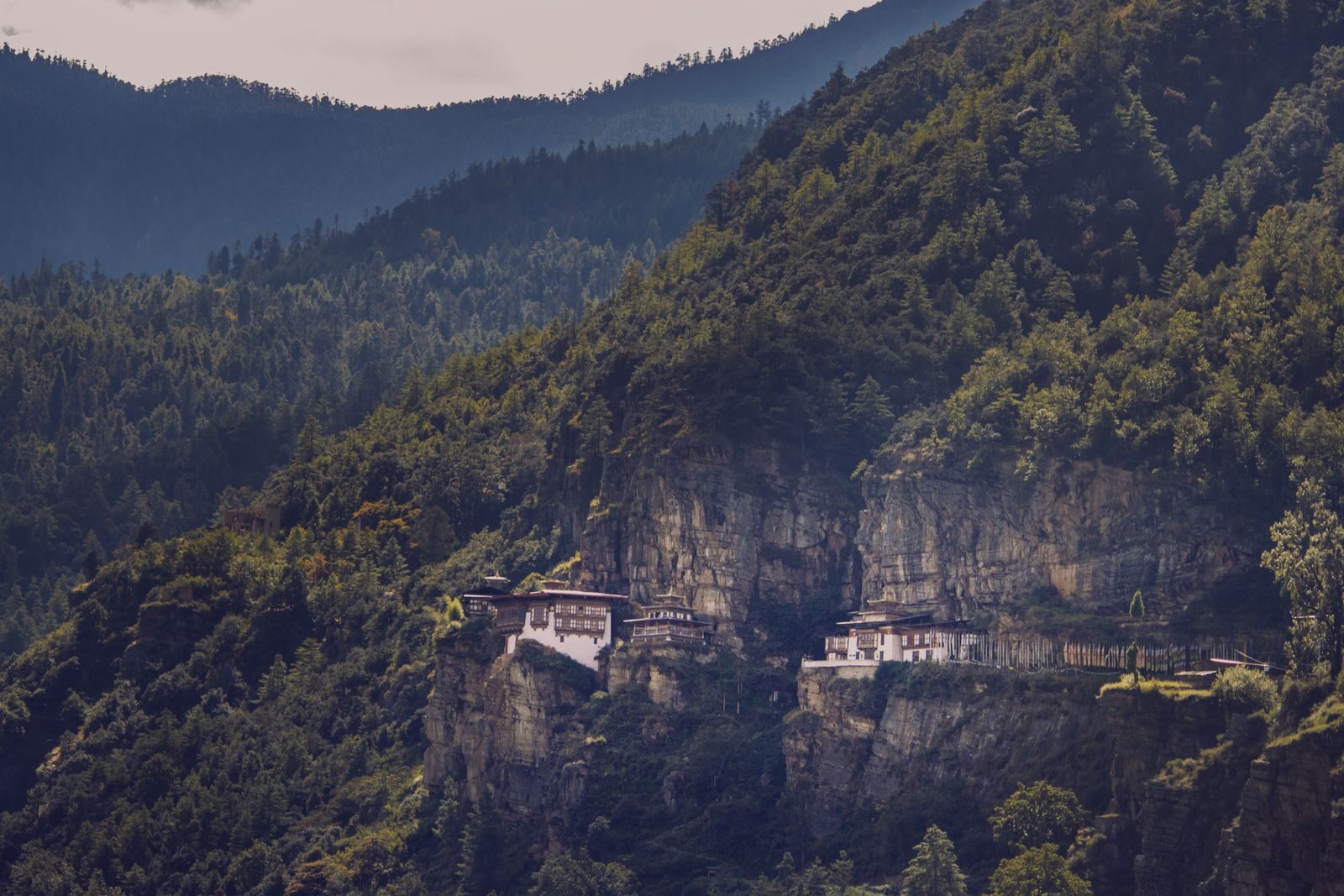
The Paro Taktsang (Tiger’s Nest) Monastery sits at 3,120m above sea level on a cliff face in the Paro Valley of Bhutan — 900m above the valley floor, the monastery complex built into and around a natural cave in the rock face where Guru Rinpoche (Padmasambhava) meditated for 3 months in the 8th century CE. The cave, the cliff, and the specific religious history make Paro Taktsang the most significant pilgrimage site in Bhutan and the most visited single location in the country.
The hike is available to visitors as part of the Bhutan SDF package. The monastery interior requires surrendering cameras and phones at the entrance (enforced). The climb is in two sections, with a café stop at the 2,750m mark before the descent into the gorge and the ascent to the monastery gates.
The Hike by Section
Section 1: Car Park (2,400m) → Café (2,750m)
Distance: 2.5km. Time: 1-1.5 hours. Elevation gain: 350m.
The initial section through the blue pine forest — the trail wide and well-maintained, the first monastery view visible at the first clearing approximately 45 minutes from the car park. The specific first view: the monastery appears as a white vertical stack against the cliff face, the scale initially unclear (the monastery is larger than it appears from this distance).
The horses: available for hire at the car park to carry visitors to the café level (BTN 1,000 / £10.94 one way). The horse path is a wider, less steep route that rejoins the main trail at the café. Appropriate for those with limited mobility or hiking experience; unnecessary for reasonably fit walkers.
The café at 2,750m:
The government-operated café gives tea, coffee, juice, and basic snacks. The terrace has the first full-frontal view of the monastery — the cliff face, the buildings, the waterfall to the right of the main complex. This is the photograph location most visitors take and mistake for the monastery approach view. The actual approach is closer and more dramatic.
Rest here: 15-20 minutes minimum. Hydrate.
Section 2: Café (2,750m) → Monastery (3,120m)
Distance: 1.5km. Time: 1-1.5 hours. Elevation gain: 370m.
The descent into the gorge (200m down on steep stone steps carved into the cliff face — the most physically demanding section of the trail, the knees bearing the descent loading) to the waterfall and the bridge spanning the gorge below the monastery. The waterfall: the specific point where the mountain water falls between the two cliff sections occupied by the monastery complex. The mist from the waterfall reaches the bridge on days of high flow.
The ascent from the bridge to the monastery gates (150m on carved stone steps): the final approach, the monastery buildings now immediately above, the scale fully apparent.
The monastery gate:
The deposit of cameras and phones (the bag is sealed and returned on exit). Entry fee: BTN 500 / £5.47. The guide accompanies visitors through the monastery.
Inside the Monastery
Four main temples connected by bridges over the gorge — the descent through the complex from the highest temple to the lowest, the route determined by the guide.
The main cave temple: The natural cave where Guru Rinpoche meditated, the interior now housing the principal shrine. The specific smell of the cave (the butter lamps, the incense, the cold rock moisture behind the lamp warmth) and the darkness broken by the lamp light: the most atmospherically charged interior in Bhutan.
The bridge views: The narrow bridges connecting the cliff sections give the most dramatic views of the monastery and the valley below. The sensation of standing on a bridge with the cliff face above and the 900m drop below — the monastery buildings visible on both sides — is the specific Tiger’s Nest moment that no photograph adequately captures.
The Timing
The morning light: The cliff face at Tiger’s Nest faces east — the buildings catch direct sun from approximately 9am, the photographs from the café viewpoint best in the 9am-11am window.
The crowd timing: Tour buses from Paro hotels arrive at 9am. The trail is busiest between 9am and noon. The afternoon (2-5pm): the trail quieter, the monastery in shadow from the cliff above, the valley below in the afternoon golden light.
The BGGD recommendation: Depart from Paro at 7am to reach the café by 9am and the monastery by 10:30am — the monastery lit, the morning tour group not yet arrived (those who started later).
The Physical Preparation
The hike is graded as moderate — appropriate for anyone who walks regularly. The elevation (the car park is at 2,400m, the monastery at 3,120m) requires some altitude adjustment for those arriving directly from low altitude. The altitude shouldn’t cause significant issues at this range for most visitors, but hydration is important (dehydration at altitude is faster than at sea level).
What to bring: Minimum 1.5L of water (the café sells drinks but at monastery prices), sunscreen (the UV at altitude is significant), a light rain jacket (the weather in the Paro Valley changes rapidly), and walking shoes with grip (the stone steps are worn smooth and wet from mist in the gorge section).