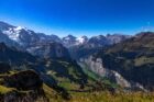
The enrosadira — the phenomenon where the Dolomite peaks turn pink, then deep rose, then red at sunset, the colour produced by the specific mineral composition of the rock and lasting exactly 12 minutes — is the reason the Dolomites are UNESCO-listed and the reason the photographs look fake. The via ferrata routes for people who’ve never climbed anything, the rifugi (mountain huts) where the schüttelbrot and the Südtiroler Speck justify the altitude, the Seceda ridgeline that is the single finest viewpoint in the Alps, the Tre Cime di Lavaredo at dawn, and why the Dolomites reward the visitor who walks above 2,000m.
Reading time: 13 minutes | Last updated: 2026
The Dolomites are not limestone in the conventional sense. They are dolomite — a mineral discovered by the French geologist Déodat Gratet de Dolomieu in 1791, who found it in these specific mountains and gave his name to both the rock and the range. The distinction matters because dolomite weathers differently from standard limestone: it erodes into the sharp, vertical, rose-pale towers that give the range its specific silhouette — and it contains calcium and magnesium in a ratio that, in the specific light of the hour before sunset, produces the enrosadira.
The enrosadira is the reason that people who are not generally mountain people go to the Dolomites. The Ladin word describes the phenomenon: the peaks turn pink as the last direct light reaches them, then deepen to rose, then to a specific red that has no English name and exists for approximately 12 minutes before the peaks go grey and the sky still holds light. The photographs are accurate. The phenomenon is real. And standing below the Seceda ridgeline or the Tre Cime di Lavaredo when it happens is one of those experiences that genuinely exceeds the preparation.
The Dolomites are also the most accessible serious mountain landscape in Europe — a UNESCO World Heritage Site in northeastern Italy, the Trentino-Alto Adige region where the Italian Alps meet the Austrian cultural tradition (the region was Austrian until 1919 — the Ladin, German, and Italian languages are all official languages here, the food is schnitzel and Südtiroler Speck and apple strudel rather than pasta, the culture is Alpine rather than Mediterranean). Cable cars reach 2,800m from the valley floor. The rifugi (mountain huts) serve hot meals. The marked trails are extensive and well-maintained.
This guide covers the enrosadira, the hiking, the via ferrata (the fixed-rope climbing routes that allow non-climbers to access vertical terrain), the rifugi, and the specific three viewpoints worth organising a trip around.
Quick Navigation
- The Enrosadira — What It Is and Where to See It
- When to Go
- Getting There — Innsbruck, Venice, Bolzano
- Where to Base — The Main Valleys
- The Seceda — The Single Finest View
- The Tre Cime di Lavaredo — The Icon
- The Alpe di Siusi — The High Plateau Meadow
- Cortina d’Ampezzo — The Resort Town
- Via Ferrata — Climbing Without Climbing
- The Rifugi — Mountain Hut Culture
- The Marmolada — The Glacier
- The Dolomite Road (Strada delle Dolomiti)
- Winter Dolomites — Skiing and Christmas Markets
- Hidden Dolomites
- What It Costs
- Eating in the Dolomites — The Alto Adige Kitchen
- Practical Notes
- The 5-Day Itinerary
The Enrosadira — What It Is and Where to See It
The enrosadira occurs because dolomite rock contains iron compounds that react to sunlight at specific wavelengths — the direct light of late evening (and, to a lesser extent, early morning) produces the specific pink-to-red colour sequence as the sun angle decreases. The effect is most visible on the highest, most exposed faces — the vertical cliff walls and the summit towers that catch the last light while the valleys below are already in shadow.
The three best enrosadira viewpoints:
Seceda (above Ortisei, Val Gardena): The cable car ascent to the Seceda ridgeline (2,518m) gives the finest overall Dolomites panorama — the Geisler Group towers visible to the south, the Val Gardena below, and the specific ridgeline walk that places you with the rock faces at eye level as the colour changes. Cable car last ascent at 5pm — check current schedules at ortisei.com. The timing: be at the ridgeline by 6pm for a 7:30pm enrosadira in summer.
Tre Cime di Lavaredo (Dolomiti di Sesto): The three vertical towers at 2,999m — the most iconic single image in the Dolomites. The enrosadira on the Tre Cime happens 20-30 minutes before the valley enrosadira (the towers are at higher altitude and catch the last light earlier). From the Rifugio Auronzo (accessible by road from Misurina, €30 / £26 road toll in season), the 9km circular walk takes 3 hours and gives the towers from every angle.
Alpe di Siusi (Seiser Alm): The high meadow plateau above Castelrotto — the Sassolungo and the Sciliar towers visible from the meadow, the sunset producing the enrosadira against the background of the high plateau grassland. The combined image (the meadow and flowers below, the pink towers above) is the most specifically alpine version of the phenomenon.
When to Go
June to September — The Hiking Season
The mountain passes open in June (some earlier, some requiring later clearance). The rifugi open from mid-June through September. The wildflowers of the high meadows peak in June-July. The weather is variable but predominantly clear — afternoon thunderstorms are common, typically clearing by evening (the enrosadira is frequently best after a thunderstorm, the cleared air giving exceptional clarity).
July and August are peak season — the rifugi full, the most popular trails (the Tre Cime circuit, the Seceda ridgeline) busy. The Dolomites are large enough that the crowds concentrate on the most accessible viewpoints; a 20-minute walk beyond them produces solitude.
September is the finest single month: the summer crowds have reduced, the high meadows are beginning their autumn colour change, the clarity of the air is at its best, and the rifugi are still fully open through September 30th.
December to March — The Ski Season
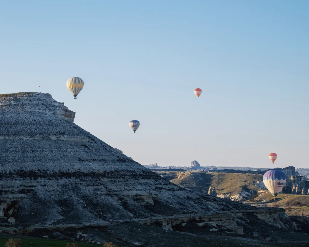
The Dolomites contain some of the finest skiing in Europe — the Sella Ronda (a 40km ski circuit around the Sella massif, crossing four valleys, one of the finest lift-linked ski routes in the Alps) and the Cortina d’Ampezzo resort are internationally significant. The Christmas markets of Bolzano (the largest and most atmospheric in Italy) and the Val Gardena in late November-December. The enrosadira in winter, on snow-covered peaks: an entirely different and equally extraordinary colour event.
October to November and April to May — Shoulder Seasons
The rifugi are closed, many cable cars not running. The valleys are accessible and beautiful; the high terrain requires winter equipment in October-November. The spring snowmelt (May) produces the most vivid wildflower season.
The BGGD recommendation: September for the full hiking experience, clear air, reduced crowds, and open rifugi.
Getting There — Innsbruck, Venice, Bolzano
The Dolomites are in northeastern Italy — the airports serving them:
Innsbruck (INN), Austria: The closest airport to the western Dolomites — 1.5 hours by road from Bolzano. easyJet from London Gatwick. Return flights: £60-150.
Venice (VCE or VCE Marco Polo): 2-3 hours from Cortina d’Ampezzo by car. easyJet, Ryanair from UK airports. Return: £50-130.
Bolzano (BZO): The regional capital, closest airport to the Val Gardena — tiny airport with limited international connections (Austrian Airlines via Vienna). Better to fly to Innsbruck or Verona and drive.
Verona (VRN): 2.5 hours to the Dolomites. Ryanair from UK airports. Return: £50-130.
The open-jaw: Fly into Innsbruck, circuit the Dolomites, fly home from Venice (or vice versa).
Getting around: Car hire essential. The mountain roads are spectacular and navigable; some passes (the Passo Gardena, the Passo Sella, the Passo Falzarego) close in winter. The Dolomites Bus service connects the main valleys in summer (useful for the Tre Cime from Cortina if not driving). Car hire from Innsbruck, Venice, or Verona: £25-40/day.
The road tolls: The Tre Cime di Lavaredo access road charges a toll (€30 / £26 per car in peak season) — the cable car from Auronzo is an alternative for non-drivers. The Alpe di Siusi is car-free above the village of Siusi — access by cable car or free bus.
Where to Base — The Main Valleys
Val Gardena (Gröden): The most centrally located valley — Ortisei (St. Ulrich), Santa Cristina, and Selva di Val Gardena as the main towns. Best access to the Seceda, the Alpe di Siusi (via Selva), and the Sella Ronda circuit. The most developed tourist infrastructure of any Dolomite valley.
Val di Fassa (Fassa Valley): The Ladin-speaking valley south of the Sella massif — Canazei and Pozza di Fassa as the main towns. Access to the Marmolada and the southern Dolomites.
Cortina d’Ampezzo: The largest Dolomite resort town — the host of the 1956 Winter Olympics, the most international in character, the most expensive. Access to the Tre Cime, the Cinque Torri, and the Dolomiti Ampezzane.
Alta Badia: The valley south of the Sella massif — La Villa, San Cassiano, Corvara. The most refined food and hotel offer in the Dolomites (including the St. Hubertus restaurant at the Rosa Alpina hotel, 3 Michelin stars).
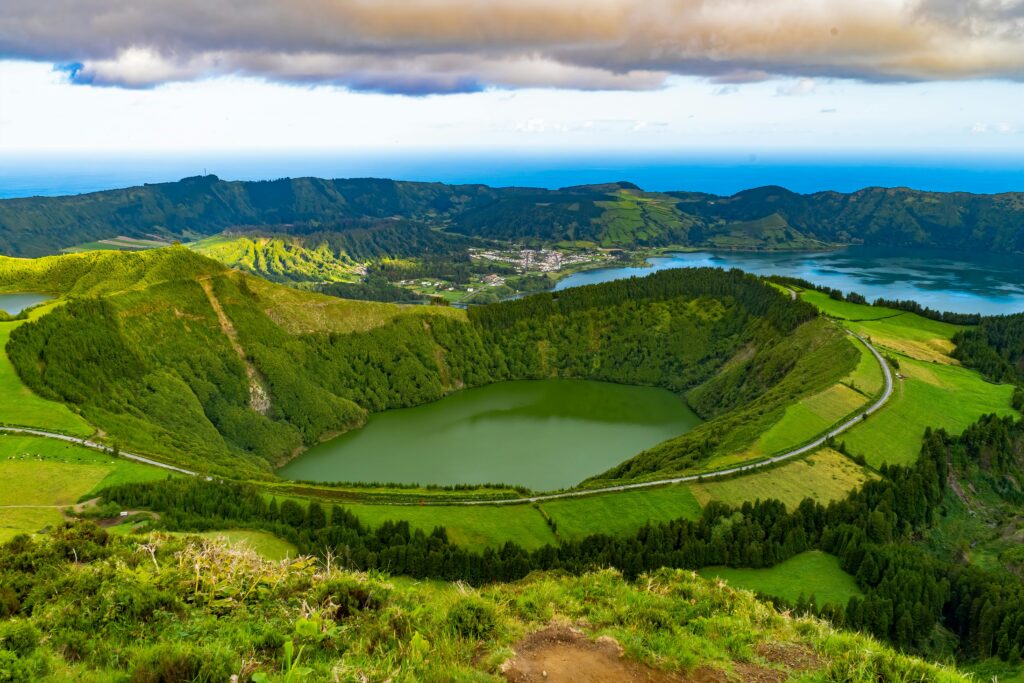
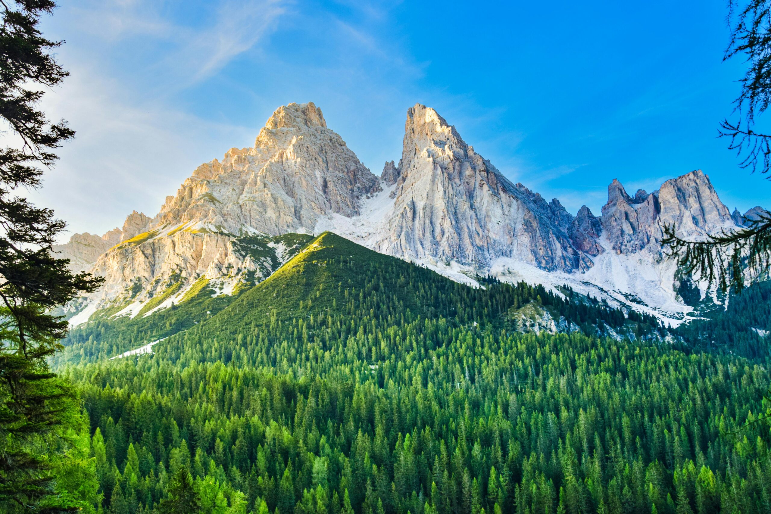
The Seceda — The Single Finest View
The Seceda ridgeline above Ortisei in the Val Gardena is, by the near-universal agreement of people who have walked extensively in the Dolomites, the finest single accessible viewpoint in the entire range.
The cable car from Ortisei ascends to 2,518m in two stages (gondola to Furnes, then cable car to Seceda). From the upper station, a 30-minute walk along the ridgeline gives the full panorama: the Geisler Group towers (Sass Rigais, 3,025m) behind the ridgeline, the Val Gardena below, the Sella massif visible to the south, the Alpe di Siusi visible to the west.
The ridgeline walk:
The Seceda ridgeline extends for 3km from the cable car station to the descent point above Ortisei — flat, well-marked, no technical difficulty. The path runs along the ridge crest with drops on both sides: the vertical faces of the Geisler Group on one side, the valley far below on the other.
At the enrosadira: the Geisler towers behind the ridgeline turn pink, then rose, then red. The specific image — the narrow ridgeline path with the pink tower faces behind it, the valley below, the sky still light — is the single most reproduced image from the Dolomites.
The descent: either return by cable car or take the 1.5-hour walking descent to Ortisei through the spruce forest below the ridgeline.
Cable car: €28 / £24 return from Ortisei. Last ascent in summer: 5pm. Confirm at ortisei.com.
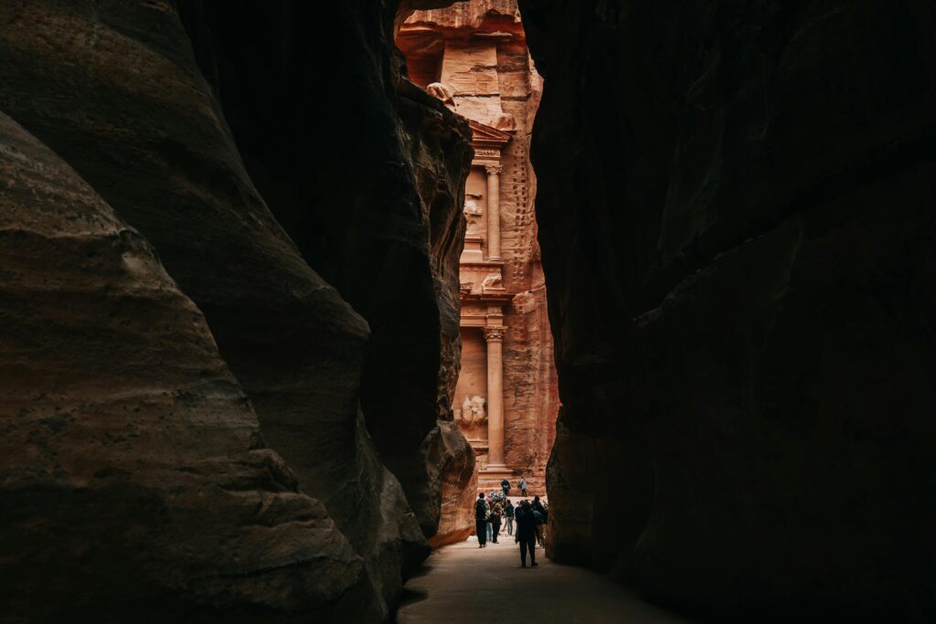
The Tre Cime di Lavaredo — The Icon
The Tre Cime di Lavaredo (Drei Zinnen in German) — three vertical dolomite towers at 2,999m, the most recognisable formation in the Dolomites — are in the Dolomiti di Sesto national park in the northeastern corner of the range, near the Austrian border.
The circular walk:
The 9km circuit around the three towers is the most walked route in the Dolomites — 3 hours at a moderate pace, minimal technical difficulty, the towers visible from every angle throughout. The full circuit gives the north face (the most vertical, the most photographed), the south face (less dramatic, the valley visible behind), and the west approach (the most theatrical arrival, the three towers appearing from behind a ridge as you round the corner from the Rifugio Lavaredo).
The timing:
Dawn — the Tre Cime at dawn is the Dolomites at their finest for the serious photographer and the serious hiker. Arrive at the Rifugio Auronzo (accessible by road) by 5:30am. The morning colour on the towers before the direct sun: 20 minutes of extraordinary light. The first tour buses from Cortina arrive at approximately 9am.
The Rifugio Lavaredo (at the north face of the towers) serves breakfast from 7am — coffee and strudel in the shadow of the towers at 7:15am is the specific rifugio experience that the Dolomites offer.
Road access:
The toll road from Misurina to the Rifugio Auronzo: €30 / £26 per car in peak season. The road is open from approximately 6am in summer. In July-August, traffic can queue significantly — arriving at 5:30am avoids this entirely.
The Alpe di Siusi — The High Plateau Meadow
The Alpe di Siusi (Seiser Alm) is the largest high-altitude meadow in Europe — 56 square kilometres of mountain pasture at 1,800-2,350m, the Sassolungo (Langkofel, 3,181m) and Sciliar (Schlern, 2,563m) towers rising from the meadow’s edge.
The specific quality: the combination of the flower meadow and the Dolomite towers is unlike anything in the Alps. The Alpe di Siusi in June (the peak wildflower season — the yellow buttercups, the blue gentians, the pink Alpenrosen) with the grey-white towers above: one of the finest single mountain landscapes in Europe.
Access:
Car-free (private vehicles prohibited above the village of Siusi in season). The cable car from Siusi village ascends in 12 minutes — €15 / £13 return. Or the free bus from Castelrotto (20 minutes). On the plateau: the Dolomites Bus connects the various huts and the trail junctions.
The walks:
The Panorama hike around the plateau (16km circular, 6 hours, no technical difficulty) gives the full range of Alpe di Siusi landscapes: the meadow, the forest edge, the cliff faces of the Sciliar, and the view back toward the Sassolungo. The shorter version (8km, 3 hours) covers the most photogenic section between the Rifugio Compatsch (the main hut, accessible from the cable car station) and the Rifugio Alpe di Tires.
Cortina d’Ampezzo — The Resort Town
Cortina is the most internationally known Dolomite resort — a wealthy ski town in the Ampezzan valley, host of the 1956 Olympics and the forthcoming 2026 Winter Olympics (jointly with Milan). The Corso Italia (the main street, the passeggiata, the outdoor table culture), the Faloria and Cristallo cable cars giving the surrounding Dolomite panorama, and the Cinque Torri (Five Towers) formation above the town.
The Cinque Torri:
A group of five isolated dolomite towers on the plateau above Cortina — accessible by chairlift (€18 / £15 return) or by a 2-hour walk from the Passo Falzarego. The towers were the site of WWI fighting — the Outdoor Museum of the Great War (an open-air museum in the positions above the towers, the Austrian and Italian trenches preserved in the rock, the view from the summit positions over the valley where both armies were positioned below) is one of the most moving and least-visited WWI sites in the Alps. Free entry to the outdoor museum.
Via Ferrata — Climbing Without Climbing
The via ferrata (iron way) is the specific Dolomites contribution to mountain access — a route up a cliff face or ridge equipped with iron rungs, pegs, and steel cables anchored to the rock, allowing people without technical climbing skills to access terrain that would otherwise require ropes and a climbing partner.
The via ferrata system in the Dolomites was developed during WWI, when Austrian and Italian armies equipped the rock faces with exactly these iron fixtures to move troops across the vertical terrain. The post-war conversion of the military infrastructure to recreational use created the most extensive via ferrata network in the Alps.
The equipment:
A via ferrata harness (a sit harness with a lanyard system — the Y-shaped lanyard clips to the steel cable throughout the route, providing fall protection), a helmet, and climbing gloves. The complete equipment set can be rented at outdoor shops in every Dolomite resort town: £18-25/day for the full kit.
The levels:
Via ferrate are graded A to F (easy to extreme). The A and B routes are accessible to anyone with no climbing experience who is comfortable with heights and moderate physical effort. The most accessible via ferrata in the Dolomites:
Via Ferrata Tridentina (Tre Cime area): Grade B, 2-3 hours, gives access to the summit plateau above the Tre Cime — the finest aerial view of the three towers available.
Via Ferrata Brigata Tridentina (Marmolada): Grade B-C, gives access to the Marmolada glacier edge.
Via Ferrata Roda di Vael (Val di Fassa): Grade B, 3-4 hours, a circular route with the finest views of the Catinaccio group.
The Rifugi — Mountain Hut Culture
The rifugio is the social infrastructure of the Dolomites — a mountain hut at altitude (typically 2,000-2,800m) serving food, drinks, and overnight accommodation to walkers, climbers, and via ferrata enthusiasts. The Dolomites have approximately 400 rifugi; the quality ranges from basic (a dormitory and a bowl of soup) to substantial (a heated dining room, a kitchen serving regional specialties, and private double rooms).
The specific rifugio experience:
Walking to a rifugio — 1-3 hours of trail from the valley or cable car — arriving with the specific appetite produced by altitude and exercise, ordering the schüttelbrot (the crispbread of the region) with Südtiroler Speck (the smoked mountain ham) and a half-litre of local beer, sitting at a wooden table on the terrace with the towers above: this is the essential Dolomites experience and it is available to anyone who can walk uphill for an hour.
Recommended rifugi:
Rifugio Seceda (2,450m, Val Gardena): At the top of the Seceda ridgeline walk — the finest terrace view in the Val Gardena. Goulash and bread at the terrace tables for £8.
Rifugio Lavaredo (2,344m, Tre Cime area): At the north face of the Tre Cime — breakfast at 7am looking at the vertical north faces. Apple strudel at altitude.
Rifugio Lagazuoi (2,752m, Falzarego): At the top of the Lagazuoi cable car above the Passo Falzarego — the WWI tunnel system in the rock below (the Lagazuoi Tunnels — the Austrian military tunnels from WWI, accessible by guided tour from the rifugio). Overnight accommodation gives sunset and sunrise enrosadira without the valley return.
Overnight stays:
Rifugi accommodation: £35-60/person per night including half board (dinner and breakfast). Book ahead in July-August. Most rifugi have an online booking system or bookable through the Dolomites Mountain Huts website (rifugidolomiti.com).
The Marmolada — The Glacier
The Marmolada (3,343m) is the highest peak in the Dolomites — the “Queen of the Dolomites” — and carries the only significant glacier in the range. The Marmolada glacier has retreated dramatically over the last 50 years (the glacier surface area has reduced by approximately 80% since 1900) and is one of the most visible examples of Alpine glacier retreat available in the Dolomites.
The cable car from Malga Ciapela ascends to 3,265m in three stages — the highest cable car station in the Dolomites. The summit panorama: the Adamello Group to the west, the Brenta Dolomites, the Austrian Alps to the north, and on exceptionally clear days the Adriatic visible to the south. The glacier visible from the viewing platform: the remaining ice, the crevasse system, and the marker showing the glacier’s extent in 1900 compared to today.
The Marmolada is also the site of one of the most catastrophic events in Dolomites recent history — the July 2022 collapse of a section of the glacier killed 11 people and injured many more. A memorial at the cable car base marks the event. The glacier access routes have been reviewed and access continues under modified safety guidelines.
Winter Dolomites — Skiing and Christmas Markets
The Sella Ronda:
The most famous ski circuit in the Dolomites — a 40km ring around the Sella massif, connecting the Val Gardena, Alta Badia, Val di Fassa, and Val Badia using 26 lifts. One full circuit takes a competent intermediate skier approximately 4-5 hours. Day ski pass for the Dolomiti Superski area: €75 / £64 — covering 1,200km of piste and all lifts in the Dolomites.
The Dolomiti Superski:
The largest interconnected ski area in the world by lift system — 450 ski lifts, 1,200km of marked runs. A single Dolomiti Superski pass covers all of it.
The Christmas markets:
Bolzano’s Weihnachtsmarkt (the largest and most atmospheric Christmas market in Italy, running from late November to January 6th) and the village markets in Ortisei, Castelrotto, and Merano give the most specifically Alpine Christmas in Italy — the mulled Glühwein, the grilled Speck, the handmade wooden ornaments from the Val Gardena woodcarving tradition.
Hidden Dolomites
The Pale di San Martino:
The largest Dolomite group by area — a high plateau of white dolomite at 2,600m, accessible from San Martino di Castrozza in the Val di Primiero. The cable car to the Rosetta hut (2,580m) deposits visitors on a lunar landscape of bare dolomite with almost no vegetation — the feeling of the high Dolomites without vegetation interference. Receives a fraction of the visitors of the Tre Cime or the Val Gardena.
The Fanes-Sennes-Braies Nature Park:
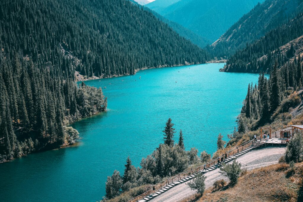
The most remote section of the central Dolomites — accessible primarily on foot or by a single road to Rifugio Fanes. The Ladin mythology of the Fanes Kingdom (a pre-Roman civilisation of the Dolomites, their stories collected in the early 20th century and comparable in scope to the Scandinavian sagas) is associated specifically with this landscape. The Pragser Wildsee (Lago di Braies) — a turquoise mountain lake accessible at the park entrance — is the most photographed lake in the Dolomites and correspondingly crowded; the park interior beyond the lake is not.
The Val Badia Vernacular Culture:
The Alta Badia valley maintains the Ladin language and culture more completely than any other Dolomite valley. The Ladin museum in San Martino in Badia covers the history and material culture of the Ladin people (the descendants of the Rhaetian and Roman populations who survived in the high valleys when the surrounding lowlands were settled by Germanic and Latin peoples). Entry: £5.
What It Costs
The Dolomites are Alpine in price — more expensive than most of the destinations in this guide, broadly comparable to Switzerland in the resort towns, significantly cheaper in the smaller villages and on self-catered hike-and-rifugio circuits.
Daily Budgets
Budget (£65-85/day)
- Accommodation: guesthouse or pension in smaller valley towns (£30-45/night)
- Food: rifugio lunches, pension dinner (£18-25/day)
- Cable cars: £15-25/day (selectively)
Mid-range (£95-135/day)
- Accommodation: mid-range hotel or rifugio overnight (£50-80/night)
- Food: quality restaurant dinners, rifugio meals (£28-40/day)
- Cable cars and activities without constraint
What 5 Days in the Dolomites Costs from the UK
| Category | Budget | Mid-Range |
|---|---|---|
| Return flights (Venice or Innsbruck) | £60–150 | £80–180 |
| Car hire 5 days | £125–180 | £150–220 |
| 5 nights accommodation | £175–280 | £320–520 |
| Food (5 days) | £100–150 | £180–260 |
| Cable cars (Seceda, Tre Cime road toll, Alpe di Siusi) | £70–90 | £80–110 |
| Via ferrata equipment hire (2 days) | £36–50 | £40–55 |
| Total | £566–900 | £850–1,345 |
Eating in the Dolomites — The Alto Adige Kitchen
The Alto Adige kitchen is the most specifically non-Italian regional cuisine in Italy — the result of the region’s Austrian history. The food is Germanic-Alpine in character: the Speck, the goulash, the Knödel, the strudel, the wine from the German varieties grown on the south-facing slopes of the Adige Valley.
Südtiroler Speck:
The defining cured meat of the region — pork leg cured with salt, pepper, rosemary, juniper, and bay, then cold-smoked over beechwood and aged for a minimum of 22 weeks. The result is a ham that is simultaneously cured (the salt preservation) and smoked (the beech smoke gives the specific flavour), the combination unlike either Italian prosciutto (not smoked) or German Schinken (more heavily smoked). The finest Speck is from mountain producers using pigs raised on the estate — at a rifugio or in a Bolzano market, sliced thin: £2-4 for a portion.
Schlutzkrapfen:
The Alto Adige pasta — half-moon filled pasta (similar to ravioli) filled with ricotta and spinach, tossed in brown butter. The dough uses rye flour (the characteristic of Alpine pasta — rye grows at altitude where wheat doesn’t). Available at every rifugio and traditional restaurant. £8-12.
Goulash:
The Austrian inheritance — a rich beef stew of paprika, onion, and potato, served with polenta or bread. The Dolomites version uses local beef and a specific paprika sourced from Hungary (the Austrian culinary link maintained in the spice market). At a rifugio on a cold September afternoon: the most restorative dish available at altitude.
Kaiserschmarrn:
The Austrian dessert — a caramelised, torn pancake dusted with powdered sugar and served with plum compote. The rifugio version, eaten at altitude after a 3-hour walk, is more satisfying than any equivalent at sea level.
Alto Adige wine:
The Adige Valley (Etschtal) and the surrounding side valleys produce wine at altitude — the cool climate giving wines of unusual elegance for the latitude. The indigenous varieties: Lagrein (a red grape producing deep, violet-tinted wines unique to Bolzano), Vernatsch (Schiava — the light red of the region, served chilled in the rifugi throughout summer), Gewürztraminer (first cultivated in the village of Tramin/Termeno in the Alto Adige — the grape’s name literally means “Traminer from Gewürz”). A glass of Lagrein at a Bolzano enoteca: £3-5.
Practical Notes
Getting there: Fly to Venice, Innsbruck, or Verona. Car hire essential. Drive time from Venice to Cortina: 2-3 hours. From Innsbruck to Bolzano: 1.5 hours.
Cable car reservations: The Seceda, Alpe di Siusi, and other popular cable cars can fill in July-August — some have online booking. The first gondola of the day is the correct time for the enrosadira the evening before (stay at altitude) or the pre-dawn approach.
Weather: Variable at altitude. The afternoon thunderstorm is a daily possibility June-August — morning starts are important. Check the mountain weather at meteo.fvg.it or bergfex.com.
Language: Italian, German, and Ladin are all official in the region. Signs are in all three languages. English spoken in tourist areas. “Danke/Grazie,” “Guten Tag/Buongiorno” — both get you everywhere.
Altitude: Most trails are at 1,800-2,800m — no altitude sickness risk, but pace yourself on the first day.
The 5-Day Itinerary
Day 1: Arrive Bolzano + Drive to Val Gardena Collect hire car at Bolzano or Innsbruck. Stop in Bolzano: the Ötzi the Iceman Museum (the 5,300-year-old mummy found in the Alps in 1991, now displayed in climate-controlled conditions — the most significant prehistoric human discovery of the 20th century, entry €14 / £12). Drive to Ortisei. Check in.
Day 2: The Seceda 9am: cable car to Seceda. Ridgeline walk (2 hours). Lunch at Rifugio Seceda. Afternoon: descent walk or return cable car. 6pm: back at the ridgeline for the enrosadira.
Day 3: Alpe di Siusi Cable car from Siusi. Panorama hike on the plateau (4-5 hours, take the full loop to the Rifugio Alpe di Tires). Lunch at a rifugio. Enrosadira from the plateau — the Sassolungo turning pink above the meadow.
Day 4: Drive East to Tre Cime — Overnight Drive via the Passo Gardena and Passo Falzarego to Misurina (2.5 hours). Afternoon: the Cinque Torri via ferrata (if equipped) or the walk from the Falzarego. Night at Rifugio Auronzo (book 4-6 weeks ahead in July-August) or in Misurina.
Day 5: Tre Cime Dawn + Drive to Venice 5:30am: road to Rifugio Auronzo. Dawn on the Tre Cime circuit. Return to Misurina by 10am. Drive to Venice (3 hours). Evening flight home.
Final Thought
I was at the Seceda ridgeline at 7:20pm on a September evening. The light had been dropping for an hour. The Geisler towers were cream, the shadows below their faces beginning to lengthen.
Then the towers changed.
Not immediately — the pink came gradually, the cream warming over approximately 4 minutes, then deepening. By the time I understood what was happening the towers were rose-coloured against a sky that was still blue. Then the rose deepened. For exactly 12 minutes — I timed it on the second occasion — the towers were a colour that English does not have a word for, somewhere between rose and red, warm in the way that stone at altitude in the last direct light of the day is warm.
Then they went grey. The sky above them held light for another 30 minutes. The towers were just towers.
The Ladin word for this is enrosadira. Twelve minutes, once a day, when the conditions are right. The specific mineral composition of the dolomite, the specific angle of the sun, the specific altitude.
Setting the alarm for the cable car last ascent is the correct response to learning that this happens.