Kazakhstan, Kyrgyzstan, Tajikistan, and Uzbekistan: the multi-country Silk Road circuit, the mountain lakes that look fabricated, the yurt culture of the Kyrgyz highlands, the Pamir Highway through the highest navigable road in the world, the Aral Sea ship graveyard, and why Central Asia is the most extraordinary multi-country overland circuit available from the UK right now.
Reading time: 14 minutes | Last updated: 2026
Central Asia is the most underwritten region in this entire guide series.
The Uzbekistan — BGGD Guide covers the Silk Road cities (Samarkand, Bukhara, Khiva, Tashkent) in detail. This guide covers the larger region — the four countries that together form the most complete Central Asian circuit: Kazakhstan, Kyrgyzstan, Tajikistan, and Uzbekistan combined into a single overland journey through the heart of the continent.
The argument for the full circuit over any single country: the landscape range is extraordinary. Uzbekistan is the desert Silk Road city culture. Tajikistan is the highest mountain passes in the world (the Pamir Highway, 4,655m at the Ak-Baital Pass) and the valleys of the Pamir plateau. Kyrgyzstan is the yurt culture of the Tian Shan highlands, the nomadic pastoral tradition still active, Lake Issyk-Kul (the second-largest alpine lake in the world). Kazakhstan is the enormity of the steppe, Almaty’s Soviet modernist architecture against the Tian Shan backdrop, and the Charyn Canyon that looks specifically like the American West in Central Asia.
None of these four countries looks like the others. All of them are accessible on the same visa-free or e-visa basis for UK passport holders. The overland connections — shared taxis, marshrutka minibuses, domestic flights — work. The guesthouses and yurt camps have developed to the level where independent travel is comfortable without being curated.
The window is now. The region has been developing its tourist infrastructure since the early 2010s and has reached the sweet spot: functional enough for independent travel, not yet mass-market.
Quick Navigation
- The Case for Central Asia — The Full Circuit
- When to Go — The Pamir Window
- Getting There — The Hub Airports
- UZBEKISTAN — The Silk Road Cities
- KAZAKHSTAN — The Steppe and Almaty
- Almaty — The Mountain City
- Charyn Canyon — The Central Asian Grand Canyon
- KYRGYZSTAN — The Nomadic Highlands
- Bishkek — The Capital
- Lake Issyk-Kul
- The Song Kul Plateau — Yurt Camp Life
- The Ala-Archa National Park
- TAJIKISTAN — The Pamirs
- Dushanbe
- The Pamir Highway (M41)
- The Wakhan Valley
- The Aral Sea — From Uzbekistan
- The Border Crossings — How They Work
- What It Costs — The Full Circuit
- Eating Across Central Asia
- Practical Notes — The Multi-Country Reality
- The 21-Day Full Circuit Itinerary
The Case for Central Asia — The Full Circuit
Central Asia sits at the crossroads of every empire that mattered: the Persian Empire, Alexander the Great’s Macedonian Empire, the Kushan Empire, the Silk Road trade networks, the Mongol Empire (which originated in the eastern steppe and transformed every city between China and Europe), the Timurid Empire, the Russian Empire, and Soviet Union. The traces of all of them are visible in the landscape.
The specific argument for doing the circuit rather than just Uzbekistan:
The landscape contrast: Uzbekistan’s desert Silk Road cities followed by Kyrgyzstan’s green mountain valleys and yurt culture followed by Tajikistan’s extreme high-altitude Pamir Highway is the most dramatic landscape sequence available in a single overland journey in Asia.
The culture contrast: The settled, urban, Islamic culture of the Uzbek Silk Road cities versus the nomadic, pastoral, Tengrist (the indigenous Central Asian nature religion, now layered with Islam) culture of the Kyrgyz highlands. Two entirely different civilisational traditions within the same region.
The logistics: The connections between the four countries work. Tashkent to Bishkek: direct flight (2 hours, from £30) or shared taxi via the border (8 hours). Bishkek to Osh (southern Kyrgyzstan): 1 hour domestic flight or 8 hours shared taxi over the mountain pass. Osh to Dushanbe: shared taxi and border crossing (1 day). Dushanbe to the Pamir: the M41 begins from Dushanbe.
The cost: Central Asia is among the best-value multi-country overland circuits in the world. Once you’ve paid for the UK-Tashkent or UK-Almaty flight (£350-550 return), the daily costs are comparable to Southeast Asia and the distance from the main tourist routes makes everything cheaper.
When to Go — The Pamir Window
June to September — The Only Pamir Window
The Pamir Highway (M41) is the dominant timing constraint for the full circuit. The highest sections (above 4,000m) are impassable or extremely dangerous from October through May due to snow. The Pamir Highway between Dushanbe and Osh via Khorog and the Wakhan Valley is fully accessible June-September and only then.
The Song Kul Plateau in Kyrgyzstan (the highland lake at 3,016m where the traditional yurt camp culture operates) is similarly June-September only — the yurt camps open in late May and close in October when the families descend to the valleys.
Uzbekistan: Year-round accessible, with the best conditions October-May (as covered in the Uzbekistan guide — the summer heat in the Silk Road cities is extreme).
The circuit timing: The full 21-day circuit works best in July or August — Uzbekistan’s cities in the early morning to avoid the heat, Kyrgyzstan and Tajikistan at maximum altitude accessibility.
May and September: The shoulder months — the high passes open in late May (sometimes June) and close in late September or October. The crowds are minimal, the prices lower. May in Kyrgyzstan: the highland flowers, fewer tourists, slightly unpredictable pass conditions. September: the harvest, the colours on the Pamir plateau, the final weeks of the yurt season.
Getting There — The Hub Airports
Tashkent (TAS), Uzbekistan:
The natural starting point for a Silk Road-first circuit. Uzbekistan Airways direct from London Heathrow. Return flights: £350-500. This is covered in full in the Uzbekistan — BGGD Guide.
Almaty (ALA), Kazakhstan:
The largest city in Kazakhstan, the commercial and cultural capital. Air Astana (the Kazakh national carrier) flies from London Heathrow via connections. Turkish Airlines via Istanbul is the most common routing. Total journey: 9-11 hours. Return flights: £400-650.
Bishkek (FRU), Kyrgyzstan:
Turkish Airlines via Istanbul and several other carriers via Moscow or Dubai. No direct UK service. Total journey: 10-13 hours. Return: £400-600.
The open-jaw strategy:
The most efficient circuit routing: fly into Tashkent, complete the circuit (Uzbekistan → Kyrgyzstan → Tajikistan → back to Uzbekistan or out via Almaty), fly home from Almaty or back from Tashkent. Open-jaw tickets on this routing are typically the same price as returns.
UZBEKISTAN — The Silk Road Cities
The Uzbekistan section of the circuit is covered in full detail in the Uzbekistan — BGGD Guide. The summary for the circuit context:
Tashkent (1-2 days): The capital, the metro (the finest Soviet-era metro outside Moscow), the Khast Imom complex, the Chorsu Bazaar.
Samarkand (2-3 days): Registan Square (the Timurid masterpiece), Shah-i-Zinda (the processional street of tilework mausoleums), Bibi-Khanym Mosque, Ulugh Beg’s Observatory.
Bukhara (2 days): The Kalon Minaret (survived Genghis Khan because he had to tilt his head back to see the top), the Lyabi-Hauz teahouse square, the covered bazaars.
Khiva (1-2 days): The most intact walled medieval city in Central Asia, 3,000 people still living inside the walls.
Transport within Uzbekistan: The Afrosiyob high-speed train (Tashkent→Samarkand→Bukhara in 3 hours total), shared taxi for Khiva.
KAZAKHSTAN — The Steppe and Almaty
Kazakhstan is the ninth-largest country in the world by area — a territory of 2.7 million square kilometres, largely flat steppe, with the Tian Shan mountains forming the southeastern border with Kyrgyzstan and China. Most of the country is effectively uninhabited; the tourist interest concentrates in the southeast (Almaty and the mountains) and the northwest (the former Aral Sea).
Visa: No visa required for UK passport holders for stays up to 30 days.
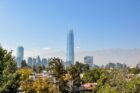
Almaty — The Mountain City
Almaty is the former capital of Kazakhstan — a Soviet-planned city of 2 million people at the base of the Tian Shan Mountains, with the snow-capped peaks visible from the city’s main streets when the air is clear. The city was the capital until 1997 (when Nur-Sultan, now Astana, was designated the new capital in a characteristically Soviet gesture — building a capital from scratch in the middle of the steppe).
Panfilov Park:
The main park of central Almaty — the Zenkov Cathedral (a 1904 wooden Russian Orthodox cathedral, built entirely without nails, the largest wooden building in Central Asia, painted in the colours of a wedding cake) and the Panfilov Memorial (the 28 Guardsmen memorial, commemorating the Kazakh soldiers who died defending Moscow in 1941). The specific Soviet-era monumental aesthetic, applied to an Orthodox Christian cathedral in a majority-Muslim country, is the visual expression of Kazakhstan’s specific civilisational layering.
The Green Bazaar (Zeleny Bazar):
The main covered market of Almaty — dried fruit and nuts (the altitude and continental climate produce extraordinary apricots, walnuts, and raisins), horse products (kazy — horsemeat sausage, the traditional Kazakh winter food), fermented horse milk (kumiss — offered at the dairy stalls, an acquired taste that most visitors try once and either immediately appreciate or politely decline), and the produce of the Kazakh agricultural tradition. The bazaar at 8am: the finest single food experience in Almaty.
The Medeu Ice Rink and Shymbulak Ski Resort:
20km above Almaty by road — the Medeu high-altitude skating rink (the highest skating rink in the world at 1,691m, used for speed skating world records in the Soviet era, now open for public skating year-round) and the Shymbulak ski resort above it. The cable car from Medeu to Shymbulak gives the finest view of the Almaty valley from above. In summer: the hiking trails above the resort reach the glacier at 3,200m.
Charyn Canyon — The Central Asian Grand Canyon
200km east of Almaty — the Charyn Canyon, a 150km limestone canyon carved by the Charyn River through the semi-arid steppe. The main viewable section (the Valley of Castles — Zamkovy Canyon): the red and ochre limestone formations eroded into towers and arches that give the canyon its nickname. The scale: 200-300m deep, the formations rising from the canyon floor.
Day trip from Almaty: shared taxi or car hire, 3 hours each way. Entry: £3. Almost empty of visitors compared to equivalent geological formations in the American West (with which the comparison is frequently made by those who have visited both).
The canyon in the early morning: the low light on the red stone, the canyon floor in shadow. One of the most satisfying geological landscapes available in Central Asia.
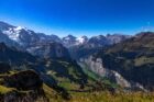
KYRGYZSTAN — The Nomadic Highlands
Kyrgyzstan is the most dramatic landscape of the four Central Asian countries in the circuit — a country that is 94% mountains, with peaks above 7,000m (Lenin Peak, 7,134m, on the Tajikistan border — the highest accessible trekking peak in Central Asia), the Tian Shan range forming the backbone, and the highland culture of the Kyrgyz nomads still partly intact.
The Kyrgyz are a Turkic people with a 1,000-year tradition of nomadic pastoralism — moving their flocks between the winter lowlands and the summer highland (jailoo) pastures with the seasons. The Soviet period disrupted but didn’t eliminate this; the post-Soviet period has seen a partial revival. The yurt camps on the high jailoos are partly traditional (families who have maintained the practice continuously) and partly community-based tourism (families who have returned to the yurt for the income it provides from trekking visitors).
Visa: No visa required for UK passport holders for stays up to 60 days.
Bishkek — The Capital
Bishkek is a Soviet-era planned city of 1.1 million people — broad tree-lined boulevards (the Soviet urban planning ideal, applied to the Kyrgyz capital in the 1920s-1960s), the central Ala-Too Square with the White House (the government building), and the specific mixture of Russian Orthodox churches, Soviet mosques, and yurt-pattern ornamentation in the architecture that reflects Kyrgyzstan’s Soviet history.
The Osh Bazaar: the main market, primarily serving the Kyrgyz domestic population — the fresh produce, the horse equipment section (the traditional Kyrgyz leather-and-felt horse gear used in the nomadic culture), the Kyrgyz felt handicrafts (shyrdak — the felt rugs with geometric patterns, available in the craft section of the market). The market at 9am: the most authentic market experience in Bishkek.
The State Historical Museum: covering Kyrgyzstan’s history from prehistoric petroglyphs through the Manas epic (the longest epic poem in world literature — the 500,000-line oral tradition of the Kyrgyz people, memorised and performed by manaschi bards, still a living tradition) to the Soviet and post-Soviet periods.
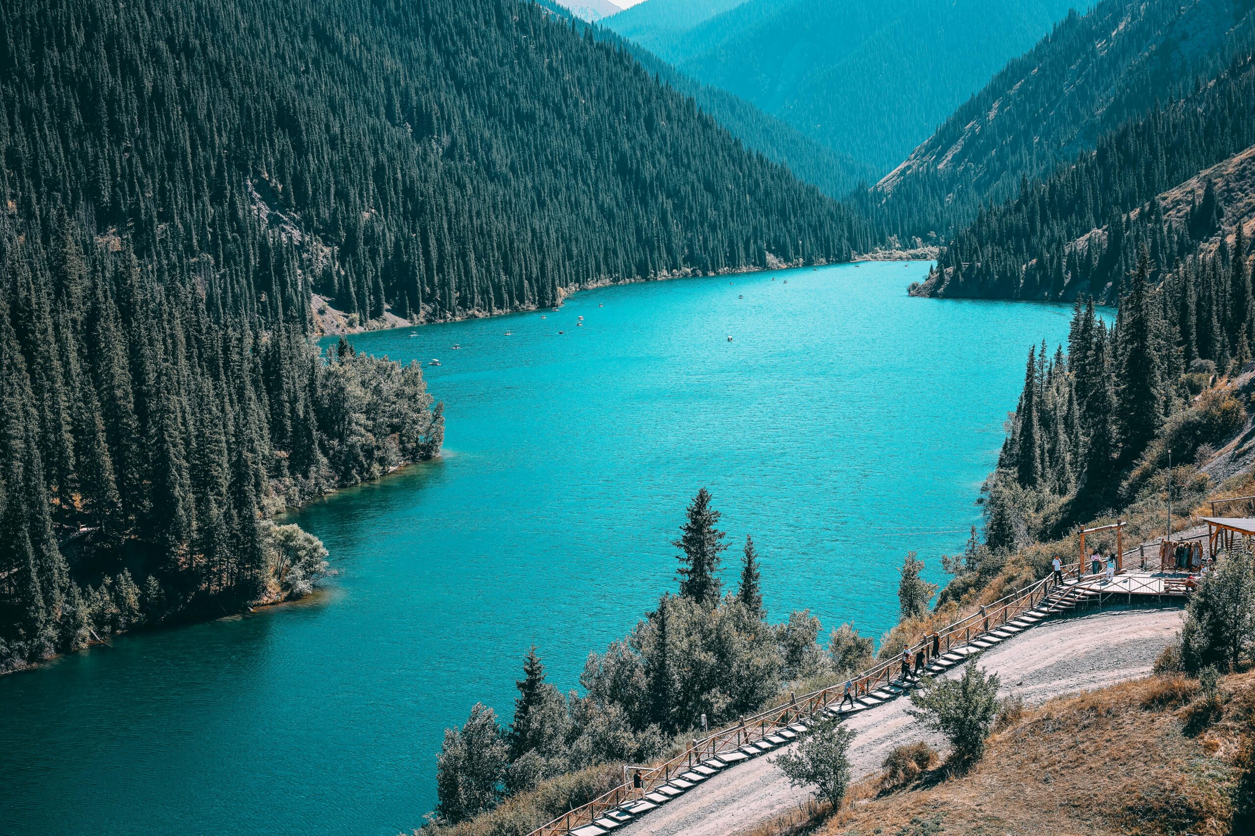
Lake Issyk-Kul
The second-largest alpine lake in the world (6,236 square kilometres, 1,607m above sea level) — a warm-water lake that doesn’t freeze in winter despite the altitude (the name means “warm lake” in Kyrgyz). The northern shore: resort towns, the Kyrgyz tourist infrastructure, the Soviet-era health sanatoria that have partially converted to tourism. The southern shore: significantly less developed, the mountains rising directly from the water, the smaller villages.
The Karakol end of the lake: the finest mountain access point. The Karakol ski resort (in winter), the Jeti-Oguz red rock canyon (the “Seven Bulls” — seven red sandstone formations on the hillside above the valley, accessible by a short walk), and the Fairy Tale Canyon (Skazka — a badlands landscape of eroded ochre and red clay formations) are all within 40km of Karakol.
Jeti-Oguz to Fairy Tale Canyon to Karakol town: a half-day circuit by shared taxi that gives three completely different landscapes in four hours.
The Song Kul Plateau — Yurt Camp Life
Song Kul is a highland lake at 3,016m in the central Tian Shan — an alpine plateau where the Kyrgyz families bring their flocks (horses, sheep, yaks) for the summer months, living in traditional yurts on the grasslands around the lake.
Getting there:
From Kochkor (a small town south of Issyk-Kul): shared taxi or hired 4WD to the plateau, 2-3 hours of mountain road including a 3,016m pass. The road is unpaved and requires a vehicle with good clearance.
The yurt camp experience:
The community tourism yurt camps on Song Kul are the primary draw — staying in a traditional felt yurt with a Kyrgyz family, eating the family’s food (kumiss, freshly baked bread, kymyz — fermented mare’s milk, the traditional highland drink, served warm in summer), watching the daily life of a pastoral community (the milking, the herding, the evening gathering of the animals). Cost: approximately £20-30/night including meals.
The dawn at Song Kul: the mist on the lake, the horses moving across the plateau, the mountains on every horizon. One of the most specifically beautiful mornings available in Central Asia.
The eagle hunters: some families maintain the traditional practice of hunting with golden eagles — a relationship between the hunter and their eagle developed over years, the eagle trained to hunt foxes and rabbits on the plateau. A visit to an eagle hunter family costs approximately £10-15 arranged through the CBT (Community Based Tourism) network at Kochkor.
The Ala-Archa National Park
40km from Bishkek — a national park in the Tian Shan foothills with accessible day hikes from 2,000m to 3,500m, the Ak-Sai Glacier visible from the upper trails, and the specific Kyrgyz mountain landscape of spruce forest and high alpine meadow.
Day trip from Bishkek: shared taxi (£3 each way), entry to the park (£3). The Ratsek Hut (3,400m) is the standard day hike destination — 6-7 hours return, moderate difficulty, the finest mountain view accessible as a day trip from a Central Asian capital.
TAJIKISTAN — The Pamirs
Tajikistan is the poorest country in the former Soviet Union and the most mountainous. The Pamir Mountains (the “Roof of the World” — a name used by travellers since the 19th century) occupy approximately 50% of the country’s territory and are home to the Pamir Highway, the second-highest international road in the world, and some of the most dramatic accessible mountain scenery on Earth.
Visa: E-visa required for UK passport holders. Apply at evisa.tj at least 7 days before travel. Cost: $50 / £39. The GBAO (Gorno-Badakhshan Autonomous Oblast) permit — required for the Pamir region — is available as an add-on to the e-visa at no extra charge. Apply both simultaneously.
Dushanbe
Tajikistan’s capital — a Soviet-planned city of 900,000 people that has been developing its infrastructure since independence in 1991. The Rudaki Park (the main central avenue), the National Museum of Tajikistan (covering Tajik history from the Sogdian period through the Samanid dynasty — one of the great Islamic civilisations of the 9th-10th centuries — to the present), and the Ismoil Somoni Square.
The specific Dushanbe experience: a capital city that is genuinely not optimised for tourists — the restaurants, the bazaars, and the daily life are primarily for the Dushanbe residents. The Green Bazaar (Bahoriston Market): the finest single market in Tajikistan, the dried apricots of the Pamirs, the walnuts of the Rasht Valley, the Tajik flat bread (non) from the tandoor ovens at the bakery stalls. The market at 7am: before the heat and before the crowds.
The Pamir Highway (M41)
The M41 is the second-highest international road in the world — 1,252km from Dushanbe (in Tajikistan) to Osh (in Kyrgyzstan), crossing the Ak-Baital Pass at 4,655m, traversing the Pamir plateau at an average altitude of 4,000m, and passing through some of the most sparsely inhabited mountain territory on Earth.
The route:
Dushanbe → Kalai Khumb (the first significant town after the Tajik capital, the road beginning to climb into the mountains) → Khorog (the capital of GBAO, a city of 30,000 in the Pyanj River valley on the Afghan border) → Ishkashim (the Afghan border town visible across the river, the Hindu Kush beginning) → Murghab (the highest town on the Pamir plateau, 3,618m, a Kyrgyz community in Tajikistan, the most isolated town on the M41) → Karakul Lake (a meteorite crater lake at 3,914m, the lake visible from the road as a deep blue disc in the brown plateau) → Ak-Baital Pass (4,655m, the highest point of the highway) → Sary-Tash (the junction for the Kyrgyz border) → Osh (the second city of Kyrgyzstan).
The logistics:
The M41 is not suitable for standard vehicles on much of its length — the road is unpaved, rutted, and at altitude where car reliability is critical. The standard approach:
Shared taxi from Dushanbe to Khorog: 12-14 hours, UDS 50-60 / £39-47 per seat. The road follows the Pyanj River (the Tajik-Afghan border) for much of the Dushanbe-Khorog section — the Afghan settlements visible across the river throughout.
Shared taxi Khorog to Murghab: 8-10 hours, the Wakhan Corridor option adding 2-3 days.
Shared taxi Murghab to Osh: 8-10 hours, the border crossing at Kyzyl-Art.
Organised jeep tour: The more comfortable and more expensive option — hire a 4WD with driver in Dushanbe or Osh for the full M41 (approximately $150-200 / £118-158 per day, typically 7-10 days for the full route). The CBT office in Dushanbe and the Murghab Ecotourism Association arrange vehicles.
The landscape:
The Pamir plateau is unlike anything in the standard travel imagination — a flat, brown, treeless wilderness at 4,000m, the scale so vast that distances are impossible to estimate, the yak herds moving across the plateau in the distance, the occasional Kyrgyz or Pamiri settlement appearing as a cluster of stone buildings against the brown. Then the road climbs to a pass and the mountains appear — white peaks above the plateau, the specific vertical scale of the Pamir.
The yaks: the plateau is grazed by yaks (Bos grunniens) — the high-altitude bovid of Central Asia, the only cattle species that can thrive above 4,000m. The yak herds on the Pamir are genuinely wild in character despite being domesticated — the animals move freely across the plateau, the herders following on horseback or foot. The specific image of a yak herd crossing the Pamir plateau is one of the finest wildlife moments available in the circuit.
The Wakhan Valley
A detour from the main M41 route — the Wakhan Corridor is the narrow strip of Afghan territory that extends east to the Chinese border, with the Wakhan Valley in Tajikistan on the northern side of the river. The valley is 300km long and accessible from the M41 at Ishkashim.
What the Wakhan contains:
The Yamchun Fortress (a 3rd-4th century BCE Zoroastrian fortress on a rock above the valley, the finest pre-Islamic archaeological site in Tajikistan), the Bibi Fatima hot springs (natural hot springs sacred to local women, in a cave above the valley), and the specific character of the most isolated valley in Central Asia — the Afghan Wakhi villages visible across the Pyanj River throughout the valley.
The Pamiri people of the Wakhan: ethnically and linguistically distinct from the Tajik majority — the Wakhi language is an Iranian language distantly related to Persian, the culture maintaining pre-Islamic elements (the Ismaili Muslim tradition of the Pamirs is significantly more liberal than Sunni Islam — music, mixed social gatherings, and many practices prohibited elsewhere in the Islamic world are maintained). The hospitality in the Wakhan homestays is the most genuine available on the full circuit.
Wakhan homestay (through the ACTED organisation or CBT): £10-15/night, meals included.
The Aral Sea — From Uzbekistan
Covered in full in the Uzbekistan — BGGD Guide. In the context of the circuit: the Aral Sea ship graveyard at Muynak (accessible from Khiva by 5-6 hour drive, or from Nukus) and the Savitsky Museum in Nukus (the world’s most important unknown museum, the Soviet avant-garde art collection saved from destruction) are the reasons to include the Karakalpakstan region in the circuit.
The ship graveyard: rusting fishing vessels stranded on a former sea bed that was underwater 40 years ago, surrounded by desert. One of the most specific and most affecting man-made landscapes available anywhere in the world.
The Border Crossings — How They Work
Uzbekistan → Kazakhstan (Gisht Kuprik/Yallama crossing): By shared taxi from Tashkent to Shymkent (Kazakhstan). The crossing: straightforward for foreign passport holders. Duration: 1-2 hours depending on queues.
Kazakhstan → Kyrgyzstan (multiple crossings): Korday crossing (between Almaty and Bishkek): the most used. The crossing: typically 30-60 minutes. Shared taxi from Almaty to Bishkek via Korday: 4-5 hours total.
Kyrgyzstan → Tajikistan (Kyzyl-Art crossing, Pamir Highway): The highest border crossing on the M41 — at approximately 4,280m. The crossing process: both Kyrgyz and Tajik border posts, typically 1-3 hours combined. Only open during daylight hours. The road between the two checkpoints is technically in neither country — a brief no-man’s-land at extreme altitude.
Kyrgyzstan (Osh) → Tajikistan (Dushanbe) alternative: direct shared taxi: Through Uzbekistan (Osh → Andijan → Tashkent → Dushanbe): a longer route but more used by travellers not doing the Pamir.
Tajikistan → Uzbekistan: Multiple crossings — the Ayni crossing (for travellers coming from the Pamir back toward Samarkand) or returning to Tashkent via the northern route.
What It Costs — The Full Circuit
Central Asia is among the finest value multi-country circuits in the world. The costs reflect economies significantly below the Western median.
Daily Budgets (All Four Countries Combined Average)
Budget (£25-38/day)
- Accommodation: guesthouse or yurt homestay (£8-18/night)
- Food: local restaurants, bazaar meals, homestay food (£5-10/day)
- Transport: shared taxis and marshrutkas
Mid-range (£45-65/day)
- Accommodation: mid-range guesthouse (£18-35/night)
- Food: better restaurants, the occasional splurge (£12-20/day)
- Organised transport for the Pamir (amortised across the trip)
What 21 Days in Central Asia Costs from the UK
| Category | Budget | Mid-Range |
|---|---|---|
| Return flights (Tashkent in, Almaty out) | £400–650 | £500–750 |
| Tajikistan e-visa + GBAO permit | £39 | £39 |
| Kazakhstan visa (UK citizens: free) | £0 | £0 |
| 21 nights accommodation | £200–380 | £480–750 |
| Food (21 days) | £120–195 | £270–440 |
| Shared taxis and marshrutkas | £80–130 | £100–160 |
| Pamir Highway transport (organised) | £200–350 | £350–550 |
| Total | £1,039–1,744 | £1,739–2,689 |
Eating Across Central Asia
The food of Central Asia reflects the nomadic and Silk Road heritage — meat-heavy, starch-based, the flavourings reflecting the spice trade routes.
Plov (Central Asian Pilaf):
The dish that runs through all four countries in variations — rice cooked in a large cast-iron kazan with lamb, carrots, onions, and garlic in cottonseed or vegetable oil. The Uzbek version (the most famous) is described in the Uzbekistan guide. The Tajik version: sometimes with chickpeas, sometimes with dried apricots. The Kyrgyz version: coarser, less refined, made in larger quantities for communal eating. In all versions: eaten communally from a single large platter.
Laghman:
Hand-pulled noodles in a meat and vegetable broth — the Central Asian noodle dish that connects the Chinese noodle tradition (brought westward along the Silk Road) with the Central Asian lamb and vegetable combination. Available throughout the circuit. The Uyghur laghman of Almaty (the city has a large Uyghur community, their laghman restaurants the finest in Kazakhstan) is the reference.
Shashlik:
Skewered grilled lamb or horse meat — the universal Central Asian street food, available from charcoal grills throughout the region. The horse shashlik (at traditional Kyrgyz and Kazakh restaurants) is the most specifically Central Asian preparation — the meat is marinated in onion and cumin, the fat content significantly higher than lamb, the flavour more intense.
Samsa:
Baked pastry filled with lamb and onion — available throughout the region, from the Uzbek versions (covered in the Uzbekistan guide) to the Kyrgyz versions (slightly different pastry texture, more onion, baked in outdoor tandoor ovens at bazaar stalls).
Kumiss (Kymyz):
Fermented mare’s milk — the traditional drink of the Kyrgyz and Kazakh nomadic cultures. Made from the milk of mares who have recently foaled (the lactation period is 5-6 months), fermented in a leather bag (the saba) or a plastic container for 24-72 hours. The result: slightly sour, slightly alcoholic (1-3%), thin and watery. Available at highland jailoo camps and at bazaars throughout Kyrgyzstan and Kazakhstan in summer. Try it once at minimum.
Kurut:
Dried balls of sour yoghurt — the preserved dairy food of the nomadic tradition, carried for weeks without refrigeration. The texture is hard and chalky; the flavour intensely sour and salty. Available at bazaars throughout Central Asia. Not immediately appealing; more interesting after the third one.
Practical Notes — The Multi-Country Reality
Visas:
- Uzbekistan: free for UK citizens
- Kazakhstan: free for UK citizens (up to 30 days)
- Kyrgyzstan: free for UK citizens (up to 60 days)
- Tajikistan: e-visa required ($50 / £39, apply at evisa.tj, add GBAO permit at the same time)
Currency:
- Uzbekistan: Uzbekistani Som (UZS) — covered in the Uzbekistan guide
- Kazakhstan: Kazakhstani Tenge (KZT). £1 ≈ 560 KZT
- Kyrgyzstan: Kyrgyzstani Som (KGS). £1 ≈ 105 KGS
- Tajikistan: Tajikistani Somoni (TJS). £1 ≈ 13 TJS
ATMs in all capital cities and major towns. Cash (USD) essential for remote areas — Murghab has no functioning ATM, the Wakhan valley has no banking infrastructure. Carry sufficient USD before leaving Khorog.
SIM cards: Available at airports and bazaars in all four countries. The coverage drops significantly in mountain areas — the Pamir plateau, Song Kul, and the Wakhan have very limited mobile coverage.
Health: Altitude is the primary concern for the Pamir. The acclimatisation principles are the same as those covered in the Nepal and Peru guides — ascend gradually, rest for 24-48 hours at intermediate altitude before the highest passes. The Ak-Baital Pass (4,655m) and the Song Kul plateau (3,016m) both require awareness. Carry altitude sickness medication if prescribed by a travel clinic.
Safety: All four countries are generally safe for tourists on the main circuits. The FCO advises caution near the Afghan border in Tajikistan — the Wakhan Valley is on the border but the specific security situation has been manageable for trekkers in recent years. Check current FCO advice before the Tajikistan section.
The 21-Day Full Circuit Itinerary
Days 1-7: Uzbekistan (Tashkent → Samarkand → Bukhara → Khiva) Covered in the Uzbekistan — BGGD Guide. The Silk Road city circuit. The Afrosiyob train.
Day 8: Khiva → Nukus (Aral Sea) Shared taxi from Khiva to Nukus (2 hours). Savitsky Museum afternoon. Overnight Nukus.
Day 9: Muynak (Aral Sea ship graveyard) Drive from Nukus to Muynak (2.5 hours). The ship graveyard. Return Nukus. Overnight bus or flight to Tashkent.
Day 10: Tashkent → Almaty (Kazakhstan) Shared taxi or flight from Tashkent to Almaty. Check in. Evening in the city.
Day 11: Almaty + Charyn Canyon Early: Charyn Canyon day trip (3 hours each way, taxi). Return afternoon. Green Bazaar evening.
Day 12: Almaty → Bishkek (Kyrgyzstan) Shared taxi via Korday border crossing (5 hours). Bishkek arrival. Ala-Archa National Park afternoon if energy allows.
Day 13: Bishkek → Issyk-Kul (Karakol end) Shared taxi east (4 hours). Jeti-Oguz canyon. Fairy Tale Canyon. Karakol overnight.
Day 14: Karakol → Song Kul (4WD, 3 hours) Book 4WD the evening before in Karakol (or arrange through CBT in Kochkor). The mountain road to Song Kul. Arrive afternoon. Yurt camp.
Day 15: Song Kul Dawn on the plateau. Eagle hunter visit. Horse riding. Kumiss. The full nomadic highland day.
Day 16: Song Kul → Osh (Kyrgyzstan) Drive south from Song Kul to Osh via Jalal-Abad (6-8 hours). Osh overnight.
Day 17: Osh → Sary-Tash → Murghab (Tajikistan) The Kyrgyzstan-Tajikistan Pamir border crossing. The drive south from Sary-Tash over the Kyzyl-Art pass into Tajikistan. Murghab overnight.
Days 18-19: Murghab → Khorog (Pamir Highway) Day 18: Karakul Lake (the meteorite crater lake, 3,914m — the most other-worldly landscape on the Pamir). Drive south and west. Day 19: Into the Wakhan Valley (the Yamchun Fortress, the Afghan border views). Khorog overnight.
Day 20: Khorog → Dushanbe 12-14 hours by shared taxi through the Pyanj River valley. The Afghanistan mountains visible throughout. Dushanbe arrival.
Day 21: Dushanbe — Departure The National Museum and Green Bazaar if the flight is afternoon. Departure from Dushanbe Airport.
Final Thought
I was at 4,655m on the Ak-Baital Pass. The vehicle had stopped to let the engine cool — standard practice at this altitude, where the air is thin enough that the engine overheats on sustained climbing.
Outside: brown plateau in every direction. No trees. No buildings. The road stretching back the way we’d come, the road continuing forward toward Kyrgyzstan. A yak herd moving across the plateau 500 metres to the north, unhurried, the animals visible as dark shapes against the brown.
The altitude: 4,655 metres. The oxygen: 58% of sea level. The temperature: 4°C in August.
The driver opened a thermos of tea and handed it back. Green tea, heavily sweetened, the specific Pamiri preparation. We sat in the car and drank tea at the highest point of the highest international road in the world.
Then the engine was cool enough. We drove on.
Central Asia gives you this — the specific pleasure of being somewhere that requires effort to reach and doesn’t reward the effort with comfort but with scale. The scale of the plateau, the scale of the passes, the scale of the distance from anywhere that resembles ordinary life.
It is exactly what a trip to Central Asia should feel like. The plov at the end of the day tastes better for it.
Question about the Central Asia circuit this guide doesn’t cover? Drop it in the comments.