
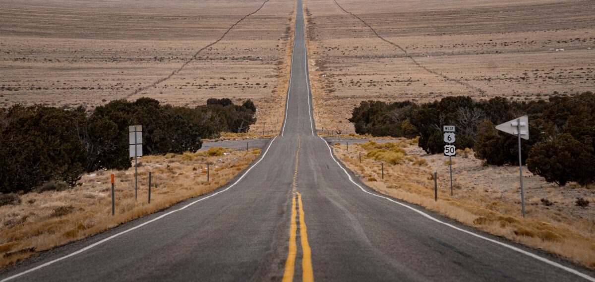
US Highway 50 across Nevada earned its “Loneliest Road in America” nickname from a 1986 Life magazine article warning drivers away from its emptiness, a label Nevada’s tourism board has since embraced entirely, turning genuine isolation into the drive’s actual selling point.
Quick answer: the full Nevada stretch of Highway 50 covers roughly 400 miles between Fernley and the Utah border, taking 3-5 days at a comfortable pace to properly explore the ghost towns, basin-and-range landscapes, and small communities along the way. This route rewards travellers specifically seeking genuine American isolation over conventional road trip sightseeing density.
Why Highway 50 Earned Its Reputation
The original 1986 warning specifically cited the vast distances between services, some stretches run 80-100+ miles without fuel, food, or any services whatsoever, a genuinely different experience from most US interstate driving. Nevada’s tourism board’s response, embracing rather than disputing the “loneliest” label and issuing a novelty “Highway 50 Survival Guide” passport for travellers to get stamped at towns along the route, turned a warning into a genuine tourism draw.
The Route at a Glance
| Section | Distance | Highlight |
|---|---|---|
| Fernley to Fallon | ~30 miles | Start point, Churchill County Museum |
| Fallon to Austin | ~110 miles | Sand Mountain, genuine desert isolation |
| Austin to Eureka | ~70 miles | Toiyabe Range, historic mining town |
| Eureka to Ely | ~78 miles | Genuinely remote basin-and-range terrain |
| Ely to Utah border | ~115 miles | Great Basin National Park detour available |
What to Actually See Along the Way
Fallon: The Last Real Town Before Isolation Begins
Fallon offers the final substantial services before the route’s emptiest stretches begin, worth a proper stop rather than a quick fuel-up.
- Churchill County Museum: free, offering genuine context on the region’s Native American, mining, and agricultural history before the drive’s emptiness sets in
- Sand Mountain: a genuinely striking 600-foot sand dune roughly 25 miles east of Fallon, free to view, with off-road vehicle access for those equipped
Austin: A Genuine Mining-Era Time Capsule
Austin, with a population under 200, sits roughly midway across the route and retains genuine 1860s silver-boom architecture, largely unchanged given the town’s subsequent economic decline rather than redevelopment.
- Stokes Castle: free to view from outside, a genuinely eccentric three-story stone tower built in 1897, now abandoned but structurally intact
- International Café and Bar: one of the few operating businesses in town, worth a stop for both food and the genuine sense of a preserved frontier-era main street
Eureka: “The Friendliest Town on the Loneliest Road”
Eureka, another former silver mining town, has genuinely leaned into its position on the route, with well-preserved 19th-century buildings and a small but functioning downtown.
- Eureka Opera House: free to view the exterior, a striking 1880 building still occasionally used for events, genuinely remarkable given the town’s tiny current population
- Eureka Sentinel Museum: free, housed in a former newspaper office, offering genuine insight into the boom-and-bust mining town history repeated across this entire route
Great Basin National Park: The Detour Worth Taking
A short detour south from the Highway 50 route near Ely reaches Great Basin National Park, one of the least-visited national parks in the entire US system, genuinely reflecting the same isolation theme as the highway itself.
- Lehman Caves guided tour: $10-$12 (£7.85-£9.40), a genuinely striking limestone cave system
- Wheeler Peak: Nevada’s second-highest peak, with a scenic drive reaching over 10,000 feet elevation, offering dramatic basin-and-range views
- Stargazing: Great Basin’s genuinely minimal light pollution makes it one of the best stargazing locations in the US, a fitting extension of the route’s isolation theme
What This Trip Actually Costs
| Category | Total for 4-5 Days (GBP, per person, based on two sharing) |
|---|---|
| Accommodation (motels, split two ways) | £120-£220 |
| Food | £85-£140 |
| Fuel (based on the full route plus detours) | £45-£70 |
| Activities/entry fees | £15-£30 |
| Total | £265-£460 |
Step-by-Step: Planning This Drive
- Fill the tank at every genuine opportunity, given the route’s famously sparse fuel stations; running low on this specific highway carries real consequences rather than minor inconvenience.
- Carry physical water and emergency supplies, since mobile signal is genuinely absent across large stretches, making self-sufficiency a practical necessity rather than an overcautious suggestion.
- Book the Highway 50 Survival Guide passport before or at the start of the trip, available through Nevada’s official tourism channels, adding a genuinely fun scavenger-hunt element to the stops along the route.
- Allow extra time for the Great Basin National Park detour, since this genuinely worthwhile addition adds a half-day or more depending on how much of the park is explored.
- Check weather conditions before winter travel specifically, since sections of the route cross mountain passes that can see genuine snow closure risk outside the main April-October travel season.
Frequently Asked Questions
Is Highway 50 actually dangerous, or is the “loneliest road” label just marketing?
Not inherently dangerous with proper preparation (fuel, water, and a general awareness of the distances involved), though the isolation is genuine rather than exaggerated, making basic road trip preparedness genuinely important rather than optional.
How long does it take to drive the full Nevada stretch of Highway 50?
The roughly 400-mile stretch can technically be driven in a single long day, but 3-5 days allows genuine time to explore the small towns and detours (Great Basin National Park specifically) that make the route worthwhile beyond simply covering the distance.
Is mobile phone signal available anywhere along the route?
Coverage exists in and immediately around the towns (Fallon, Austin, Eureka, Ely) but drops out entirely across the long stretches between them, genuinely consistent with the route’s overall isolation theme.
What is the best time of year to drive Highway 50?
May through October offers the most reliable conditions, avoiding winter mountain pass closures and extreme summer desert heat that can affect the route’s more exposed sections during peak summer months.
Where to Start and End the Drive
Most travellers approach Highway 50 from Reno, roughly an hour’s drive to Fernley where the genuinely isolated stretch of the route begins, making Reno the practical starting point given its international airport connections. The route’s eastern end connects into Utah near Great Basin National Park, with Salt Lake City offering a reasonable onward connection point for travellers not looping back to Reno, worth factoring into flight booking if approaching this as a one-way rather than round-trip drive.
The Bottom Line
Highway 50 delivers genuine American isolation, small preserved mining towns, dramatic basin-and-range desert landscapes, and one of the country’s least-visited national parks, all built around a “loneliest road” reputation that’s earned rather than manufactured. The trade-off is a trip requiring genuine preparation for the route’s real isolation, fuel planning and self-sufficiency matter here in a way most conventional US road trips don’t demand.